
15 June 2020
Nick Carne
Studies explore mountains and movement near mantle.
Scientists continue to explore how our planet formed and how it works, with often surprising results.
In recent separate studies, researchers have developed a theory for what controls the height of mountains and used a technique designed to better understand space to take a closer look at structures inside the Earth.
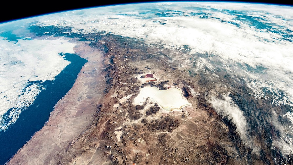
The height of the Andes, and other mountain ranges on Earth, is determined by tectonic forces, researchers say. Credit: NASA; Astronaut photograph ISS059-E-517.
Whether the height of mountain ranges is mainly determined by tectonic processes in the Earth’s interior or by erosional processes sculpting its surface has long been debated in geosciences.
Now a German team, writing in the journal Nature, reports that its research points to the former – to an equilibrium of forces in the Earth’s crust.
They came to this conclusion, they say, by calculating the forces along different plate boundaries on the Earth.

Armin Dielforder from GFZ German Research Centre for Geoscience and colleagues from GFZ and the University of Münster collected data from the literature on friction in the subsurface of mountain ranges of different height and calculated the resulting stress and thus the forces that lead to the uplift of the respective mountains.
In this way, they say, they showed that in active mountains the force on the plate boundary and the forces resulting from the weight and height of the mountains are in balance. Such a balance of forces exists in all the mountain ranges studied, although they are located in different climatic zones with widely varying erosion rates.
This result shows, the researchers add, that mountain ranges are able to react to processes on the Earth’s surface and to grow with rapid erosion in such a way that the balance of forces and the height of the mountain range are maintained.
In the second study, described in a paper in the journal Science, researchers from the US and Israel were able to create a map showing details of the Earth’s mantle, just above the liquid iron core, at a depth of 3000 kilometres.

Using a new technique originally designed to explore the cosmos, scientists have unveiled structures deep inside the Earth, paving the way for a new map revealing what Earth’s interior looks like. [from https://hub.jhu.edu/2020/06/12/sequencer-mapping-earth-science/ ]
Their analysis focused on the Pacific Ocean, revealing a previously unknown structure beneath the volcanic Marquesas Islands and showing that the structure beneath the Hawaiian Islands is much larger than previously known.
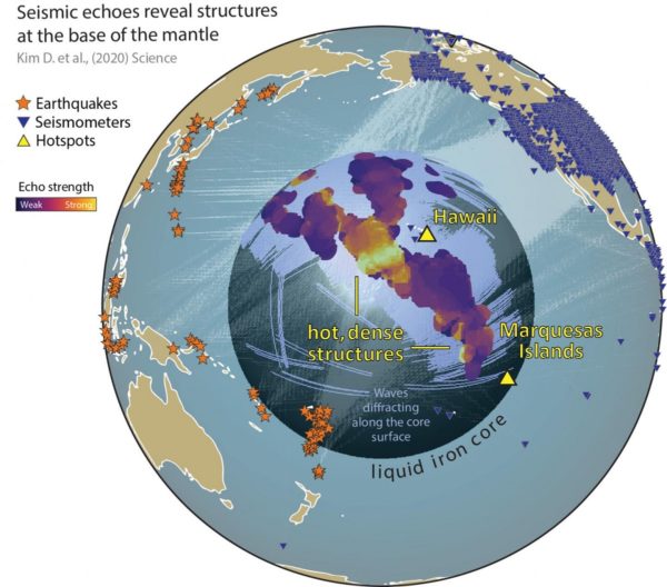
Credit: Doyeon Kim/University of Maryland
As Meghan S Miller from the Australian National University notes in a related commentary [Science], they were able to detect subtle changes in seismic waveforms from earthquakes that occurred in Asia and Oceania and were recorded in the Americas, mapping their origins across a large geographic region.
The project brought together researchers from the University of Maryland and Johns Hopkins University (JHU) in the US and Israel’s Tel Aviv University, but the star of the show was a novel algorithm called the Sequencer.
Earthquakes send sound waves through the Earth, and seismograms record the echoes as those waves travel along the core-mantle boundary, diffracting and bending around dense rock structures.
These are valuable but somewhat limited, not the least being the data is restricted to a specific time and a tiny region, and it’s often impossible to distinguish weaker echoes from noise.
The Sequencer, which was designed to find interesting trends in astronomical datasets, was able to analyse thousands of seismograms collected over three decades and look for patterns.
In fact, says JHU astrophysicist Brice Ménard, who developed it with graduate student Dalya Baron, it can automatically find interesting trends in any type of dataset.
“With this new way to look at the data globally, we were able to see weak signals much more clearly,” he says. “We were finally able to identify the seismic echoes and use them to create a map.”
Looking at thousands of core-mantle boundary echoes at once, instead of focussing on a few at a time, provided a totally new perspective, says Maryland seismologist Doyeon Kim, the paper’s lead author.
“This is showing us that the core-mantle boundary region has lots of structures that can produce these echoes, and that was something we didn’t realise before because we only had a narrow view,” he says.
In fact, the study found echoes on about 40% of all seismic wave paths, which surprised Maryland geologist Vedran Lekic. “We were expecting them to be more rare, and what that means is the anomalous structures at the core-mantle boundary are much more widespread than previously thought.”
The large patch of very dense, hot material at the core-mantle boundary beneath Hawaii produced uniquely loud echoes, indicating that it is even larger than previous estimates.
Known as ultralow-velocity zones (ULVZs), such patches are found at the roots of volcanic plumes, where hot rock rises from the core-mantle boundary region to produce volcanic islands. The ULVZ beneath Hawaii is the largest known.
See the full article here .
See a related article here.

five-ways-keep-your-child-safe-school-shootings
Please help promote STEM in your local schools.
![]()
