From The University of Texas-Austin: “Surviving a Volcanic Supereruption May Have Facilitated Human Dispersal Out of Africa”

From The University of Texas-Austin

3.20.24

Media Contact
Alex Reshanov
College of Liberal Arts
areshanov@austin.utexas.edu

1

Researchers working in the Horn of Africa have uncovered evidence showing how Middle Stone Age humans survived in the wake of the eruption of Toba, one of the largest supervolcanoes in history, some 74,000 years ago. The behavioral flexibility of these Middle Stone Age people not only helped them live through the supereruption but may have facilitated the later dispersal of modern humans out of Africa and across the rest of the world.

Modern humans dispersed from Africa multiple times, but the event that led to global expansion occurred less than 100,000 years ago. Some researchers hypothesize that dispersals were restricted to “green corridors” formed during humid intervals when food was abundant and human populations expanded in lockstep with their environments. But a new study in Nature led by scientists at The University of Texas at Austin suggests that humans also may have dispersed during arid intervals along “blue highways” created by seasonal rivers. Researchers also found stone tools that represent the oldest evidence of archery.

2
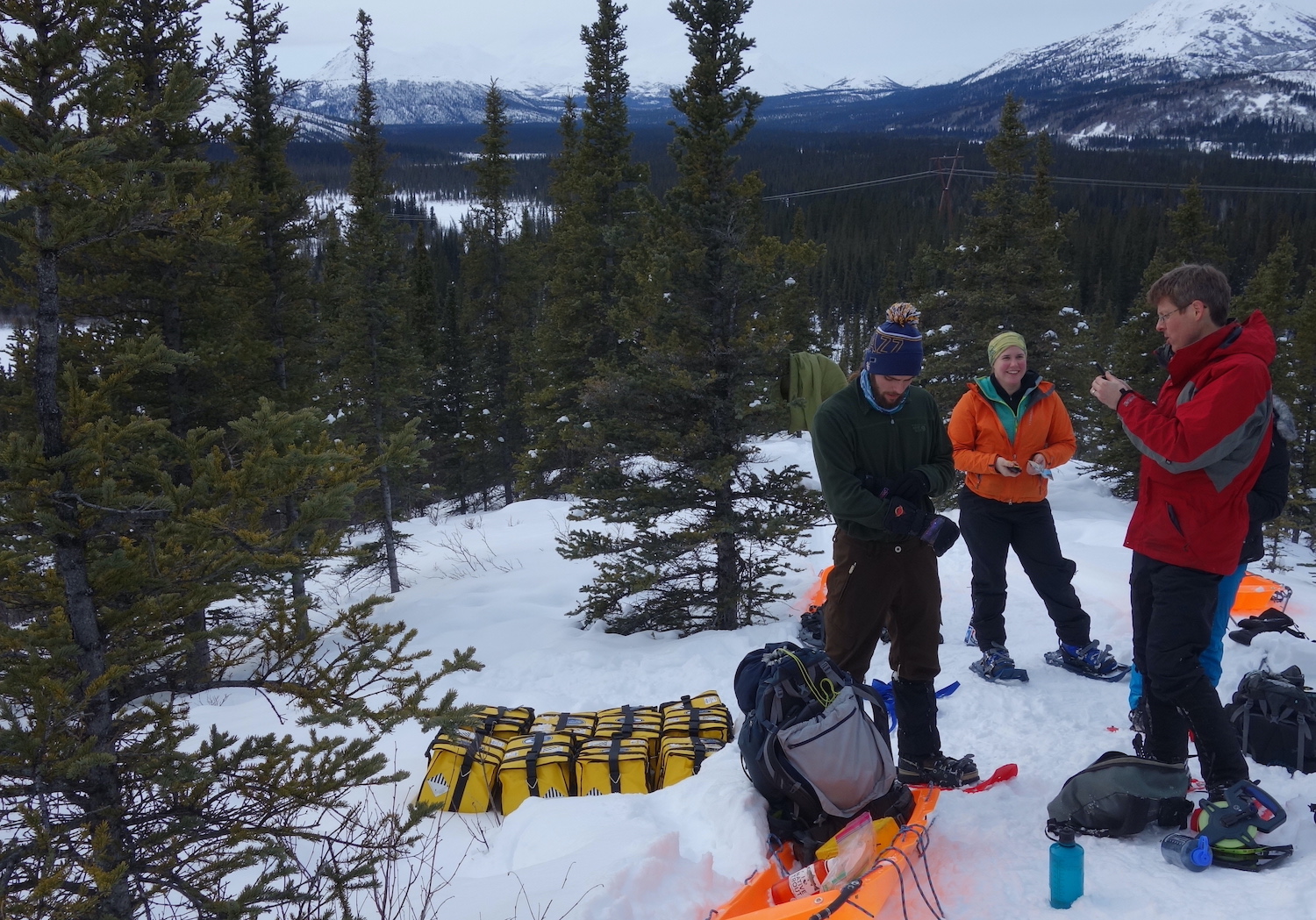
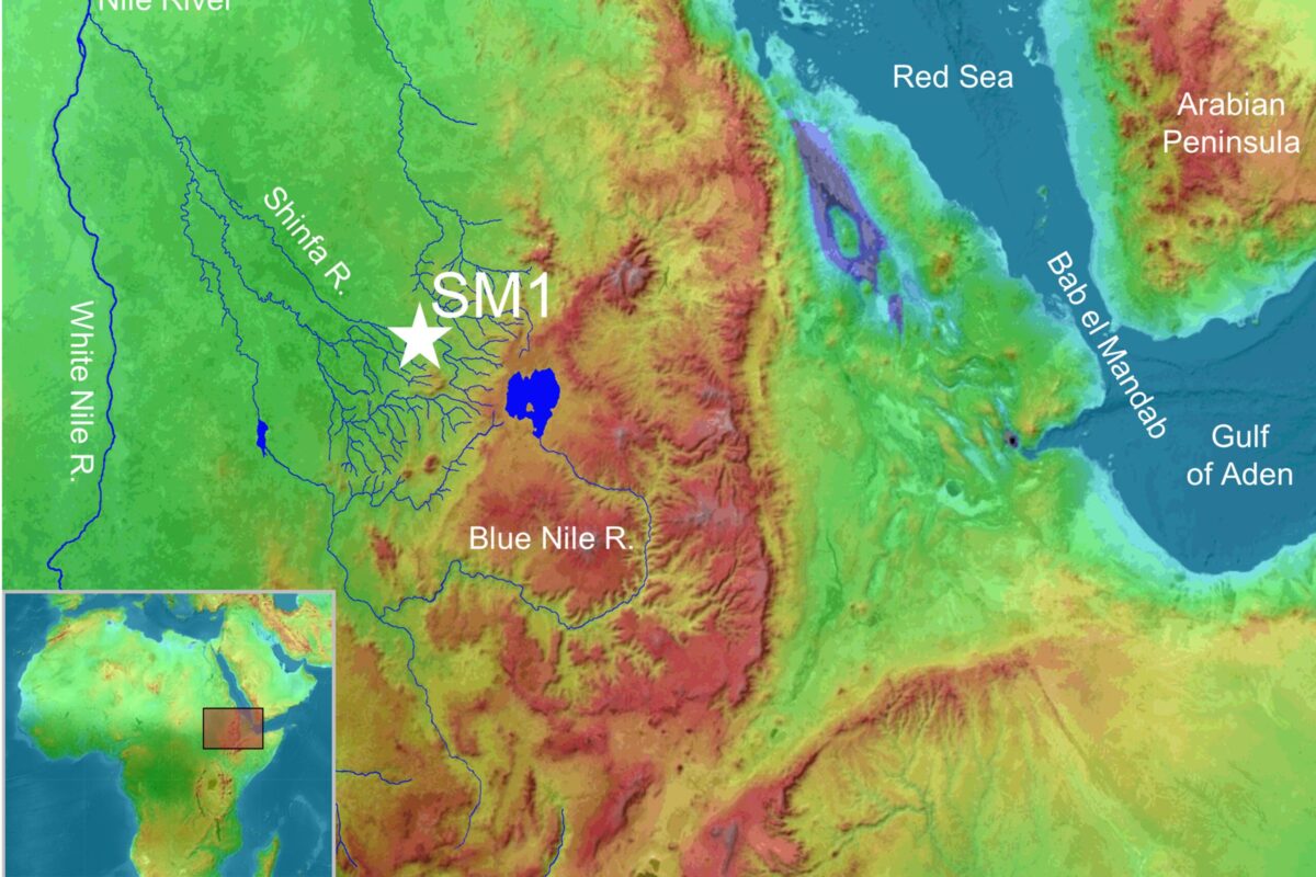
Excavations at a Middle Stone Age archaeological site, Shinfa-Metema 1, in the lowlands of northwest Ethiopia revealed a population of humans at 74,000 years ago that survived the eruption of the Toba supervolcano.

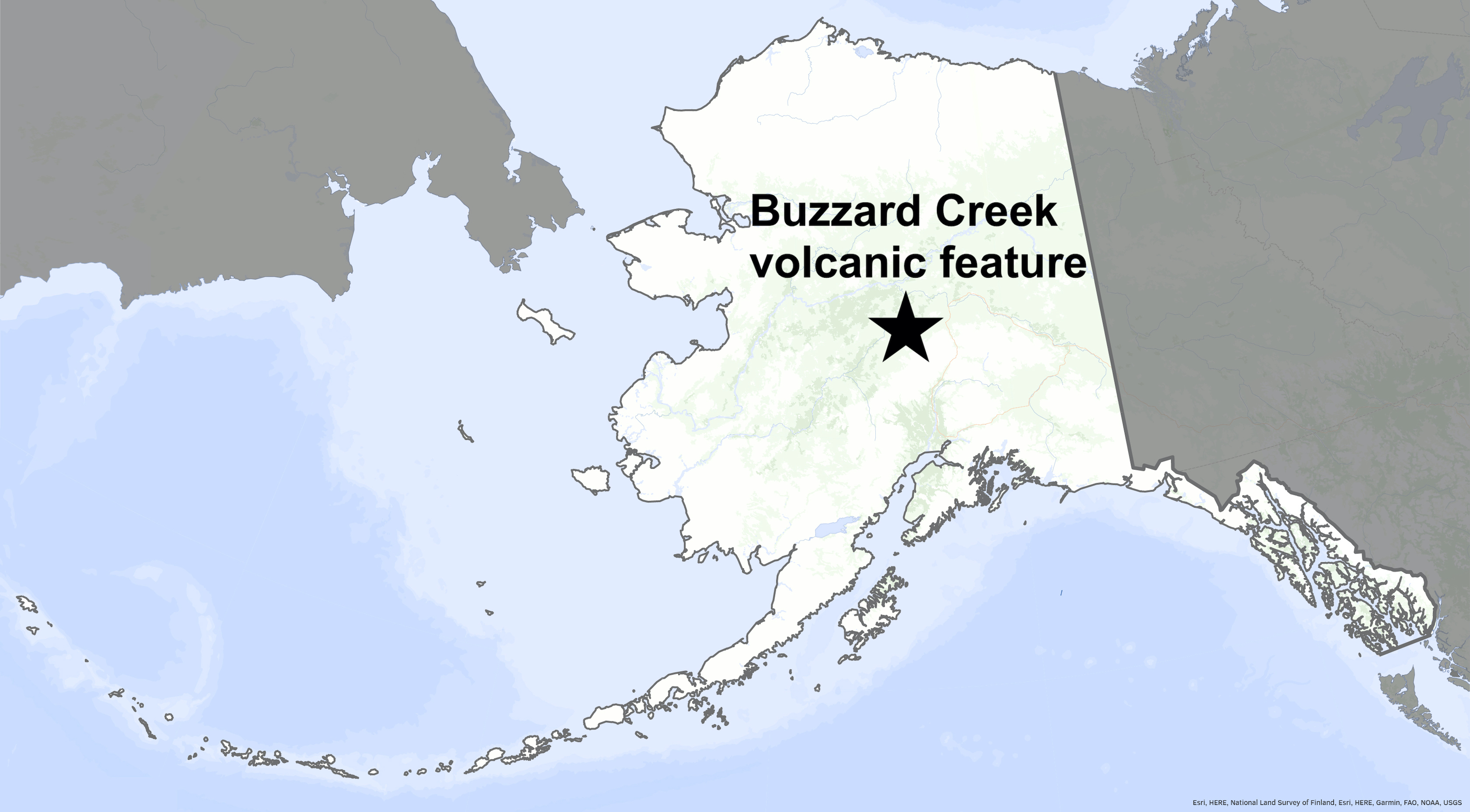
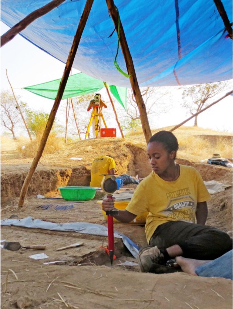
The team investigated the Shinfa-Metema 1 site in the lowlands of present-day northwestern Ethiopia along the Shinfa River, a tributary of the Blue Nile River. Based on isotope geochemistry of the teeth of fossil mammals and ostrich eggshells, they concluded that the site was occupied by humans during a time with long dry seasons on par with some of the most seasonally arid habitats in East Africa today. Additional findings suggest that when river flows stopped during dry periods, people adapted by hunting animals that came to the remaining waterholes to drink. As waterholes continued to shrink, it became easier to capture fish without any special equipment, and diets shifted more heavily to fish.

The supereruption occurred during the middle of the time when the site was occupied and is documented by tiny glass shards whose chemistry matches that of Toba. Its climatic effects appear to have produced a longer dry season, causing people in the area to rely even more on fish. The shrinking of the waterholes may also have pushed humans to migrate outward in search of more food.

“As people depleted food in and around a given dry season waterhole, they were likely forced to move to new waterholes,” said John Kappelman, a UT anthropology and earth and planetary sciences professor and lead author of the study. “Seasonal rivers thus functioned as ‘pumps’ that siphoned populations out along the channels from one waterhole to another, potentially driving the most recent out-of-Africa dispersal.”

The humans who lived at Shinfa-Metema 1 are unlikely to have been members of the group that left Africa. However, the behavioral flexibility that helped them adapt to challenging climatic conditions such as the Toba supereruption was probably a key trait of Middle Stone Age humans that allowed our species to ultimately disperse from Africa and expand across the globe.

The people living in the Shinfa-Metema 1 site hunted a variety of terrestrial animals, from antelope to monkey, as attested to by cut marks on the bones, and apparently cooked their meals as shown by evidence of controlled fire at the site. The most distinctive stone tools are small, symmetrical triangular points.

3
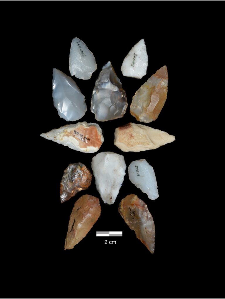
Projectile points from a Middle Stone Age archaeological site, Shinfa-Metema 1, in the lowlands of northwest Ethiopian dating from the time of the Toba supereruption at 74,000 years ago provide evidence for bow and arrow use prior to the dispersal of modern humans out of Africa. Photograph by Blue Nile Survey Project.

“Analyses show that the points are most likely arrowheads that, at 74,000 years in age, represent the oldest evidence of archery,” Kappelman said. “The Ethiopian Heritage Authority has made 3D scans of the points available so that anyone anywhere in the world can download the files and evaluate the hypothesis for themselves.”

See the full article here .

Comments are invited and will be appreciated, especially if the reader finds any errors which I can correct.

five-ways-keep-your-child-safe-school-shootings

Please help promote STEM in your local schools.

Stem Education Coalition

University of Texas-Austin

University of Texas-Austin campus

The University of Texas-Austin is a public research university in Austin, Texas and the flagship institution of the University of Texas System. Founded in 1883, the University of Texas was inducted into the Association of American Universities in 1929, becoming only the third university in the American South to be elected. The institution has one of the nation’s largest single-campus enrollment, with over 60,000 undergraduate and graduate students and over 25,000 faculty and staff.

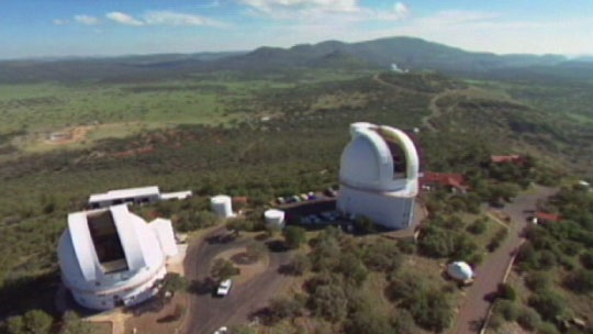
A “Public Ivy”, it is a major center for academic research. The university houses seven museums and seventeen libraries, including the LBJ Presidential Library and the Blanton Museum of Art, and operates various auxiliary research facilities, such as the J. J. Pickle Research Campus and the McDonald Observatory.

U Texas McDonald Observatory Campus, Altitude 2,070 m (6,790 ft).

Nobel Prize winners, Pulitzer Prize winners, Turing Award winners, Fields medalists, Wolf Prize winners, and Abel prize winners have been affiliated with the school as alumni, faculty members or researchers. The university has also been affiliated with Primetime Emmy Award winners, and has produced many Olympic medalists.

Student-athletes compete as the Texas Longhorns. Its Longhorn Network is the only sports network featuring the college sports of a single university. The Longhorns have won NCAA Division I National Football Championships, NCAA Division I National Baseball Championships, NCAA Division I National Men’s Swimming and Diving Championships, and has claimed more titles in men’s and women’s sports than any other school in the Big 12 since the league was founded in 1996.

Establishment

The first mention of a public university in Texas can be traced to the 1827 constitution for the Mexican state of Coahuila y Tejas. Although Title 6, Article 217 of the Constitution promised to establish public education in the arts and sciences, no action was taken by the Mexican government. After Texas obtained its independence from Mexico in 1836, the Texas Congress adopted the Constitution of the Republic, which, under Section 5 of its General Provisions, stated “It shall be the duty of Congress, as soon as circumstances will permit, to provide, by law, a general system of education.”

On April 18, 1838, “An Act to Establish the University of Texas” was referred to a special committee of the Texas Congress, but was not reported back for further action. On January 26, 1839, the Texas Congress agreed to set aside fifty leagues of land—approximately 288,000 acres (117,000 ha)—towards the establishment of a publicly funded university. In addition, 40 acres (16 ha) in the new capital of Austin were reserved and designated “College Hill”. (The term “Forty Acres” is colloquially used to refer to the University as a whole. The original 40 acres is the area from Guadalupe to Speedway and 21st Street to 24th Street.)

In 1845, Texas was annexed into the United States. The state’s Constitution of 1845 failed to mention higher education. On February 11, 1858, the Seventh Texas Legislature approved O.B. 102, an act to establish the University of Texas, which set aside $100,000 in United States bonds toward construction of the state’s first publicly funded university (the $100,000 was an allocation from the $10 million the state received pursuant to the Compromise of 1850 and Texas’s relinquishing claims to lands outside its present boundaries). The legislature also designated land reserved for the encouragement of railroad construction toward the university’s endowment. On January 31, 1860, the state legislature, wanting to avoid raising taxes, passed an act authorizing the money set aside for the University of Texas to be used for frontier defense in west Texas to protect settlers from Indian attacks.

Texas’s secession from the Union and the American Civil War delayed repayment of the borrowed monies. At the end of the Civil War in 1865, The University of Texas’s endowment was just over $16,000 in warrants and nothing substantive had been done to organize the university’s operations. This effort to establish a University was again mandated by Article 7, Section 10 of the Texas Constitution of 1876 which directed the legislature to “establish, organize and provide for the maintenance, support and direction of a university of the first class, to be located by a vote of the people of this State, and styled “The University of Texas”.

Additionally, Article 7, Section 11 of the 1876 Constitution established the Permanent University Fund, a sovereign wealth fund managed by the Board of Regents of the University of Texas and dedicated to the maintenance of the university. Because some state legislators perceived an extravagance in the construction of academic buildings of other universities, Article 7, Section 14 of the Constitution expressly prohibited the legislature from using the state’s general revenue to fund construction of university buildings. Funds for constructing university buildings had to come from the university’s endowment or from private gifts to the university, but the university’s operating expenses could come from the state’s general revenues.

The 1876 Constitution also revoked the endowment of the railroad lands of the Act of 1858, but dedicated 1,000,000 acres (400,000 ha) of land, along with other property appropriated for the university, to the Permanent University Fund. This was greatly to the detriment of the university as the lands the Constitution of 1876 granted the university represented less than 5% of the value of the lands granted to the university under the Act of 1858 (the lands close to the railroads were quite valuable, while the lands granted the university were in far west Texas, distant from sources of transportation and water). The more valuable lands reverted to the fund to support general education in the state (the Special School Fund).

On April 10, 1883, the legislature supplemented the Permanent University Fund with another 1,000,000 acres (400,000 ha) of land in west Texas granted to the Texas and Pacific Railroad but returned to the state as seemingly too worthless to even survey. The legislature additionally appropriated $256,272.57 to repay the funds taken from the university in 1860 to pay for frontier defense and for transfers to the state’s General Fund in 1861 and 1862. The 1883 grant of land increased the land in the Permanent University Fund to almost 2.2 million acres. Under the Act of 1858, the university was entitled to just over 1,000 acres (400 ha) of land for every mile of railroad built in the state. Had the 1876 Constitution not revoked the original 1858 grant of land, by 1883, the university lands would have totaled 3.2 million acres, so the 1883 grant was to restore lands taken from the university by the 1876 Constitution, not an act of munificence.

On March 30, 1881, the legislature set forth the university’s structure and organization and called for an election to establish its location. By popular election on September 6, 1881, Austin (with 30,913 votes) was chosen as the site. Galveston, having come in second in the election (with 20,741 votes), was designated the location of the medical department (Houston was third with 12,586 votes). On November 17, 1882, on the original “College Hill,” an official ceremony commemorated the laying of the cornerstone of the Old Main building. University President Ashbel Smith, presiding over the ceremony, prophetically proclaimed “Texas holds embedded in its earth rocks and minerals which now lie idle because unknown, resources of incalculable industrial utility, of wealth and power. Smite the earth, smite the rocks with the rod of knowledge and fountains of unstinted wealth will gush forth.” The University of Texas officially opened its doors on September 15, 1883.

Expansion and growth

In 1890, George Washington Brackenridge donated $18,000 for the construction of a three-story brick mess hall known as Brackenridge Hall (affectionately known as “B.Hall”), one of the university’s most storied buildings and one that played an important place in university life until its demolition in 1952.

The old Victorian-Gothic Main Building served as the central point of the campus’s 40-acre (16 ha) site, and was used for nearly all purposes. But by the 1930s, discussions arose about the need for new library space, and the Main Building was razed in 1934 over the objections of many students and faculty. The modern-day tower and Main Building were constructed in its place.

In 1910, George Washington Brackenridge again displayed his philanthropy, this time donating 500 acres (200 ha) on the Colorado River to the university. A vote by the regents to move the campus to the donated land was met with outrage, and the land has only been used for auxiliary purposes such as graduate student housing. Part of the tract was sold in the late-1990s for luxury housing, and there are controversial proposals to sell the remainder of the tract. The Brackenridge Field Laboratory was established on 82 acres (33 ha) of the land in 1967.

In 1916, Gov. James E. Ferguson became involved in a serious quarrel with the University of Texas. The controversy grew out of the board of regents’ refusal to remove certain faculty members whom the governor found objectionable. When Ferguson found he could not have his way, he vetoed practically the entire appropriation for the university. Without sufficient funding, the university would have been forced to close its doors. In the middle of the controversy, Ferguson’s critics brought to light a number of irregularities on the part of the governor. Eventually, the Texas House of Representatives prepared 21 charges against Ferguson, and the Senate convicted him on 10 of them, including misapplication of public funds and receiving $156,000 from an unnamed source. The Texas Senate removed Ferguson as governor and declared him ineligible to hold office.

In 1921, the legislature appropriated $1.35 million for the purchase of land next to the main campus. However, expansion was hampered by the restriction against using state revenues to fund construction of university buildings as set forth in Article 7, Section 14 of the Constitution. With the completion of Santa Rita No. 1 well and the discovery of oil on university-owned lands in 1923, the university added significantly to its Permanent University Fund. The additional income from Permanent University Fund investments allowed for bond issues in 1931 and 1947, which allowed the legislature to address funding for the university along with the Agricultural and Mechanical College (now known as Texas A&M University). With sufficient funds to finance construction on both campuses, on April 8, 1931, the Forty Second Legislature passed H.B. 368. which dedicated the Agricultural and Mechanical College a 1/3 interest in the Available University Fund, the annual income from Permanent University Fund investments.

The University of Texas was inducted into The Association of American Universities in 1929. During World War II, the University of Texas was one of 131 colleges and universities nationally that took part in the V-12 Navy College Training Program which offered students a path to a Navy commission.

In 1950, following Sweatt v. Painter, the University of Texas was the first major university in the South to accept an African-American student. John S. Chase went on to become the first licensed African-American architect in Texas.

In the fall of 1956, the first black students entered the university’s undergraduate class. Black students were permitted to live in campus dorms, but were barred from campus cafeterias. The University of Texas integrated its facilities and desegregated its dorms in 1965. UT, which had had an open admissions policy, adopted standardized testing for admissions in the mid-1950s at least in part as a conscious strategy to minimize the number of Black undergraduates, given that they were no longer able to simply bar their entry after the Brown decision.

Following growth in enrollment after World War II, the university unveiled an ambitious master plan in 1960 designed for “10 years of growth” that was intended to “boost the University of Texas into the ranks of the top state universities in the nation.” In 1965, the Texas Legislature granted the university Board of Regents to use eminent domain to purchase additional properties surrounding the original 40 acres (160,000 m^2). The university began buying parcels of land to the north, south, and east of the existing campus, particularly in the Blackland neighborhood to the east and the Brackenridge tract to the southeast, in hopes of using the land to relocate the university’s intramural fields, baseball field, tennis courts, and parking lots.

On March 6, 1967, the Sixtieth Texas Legislature changed the university’s official name from “The University of Texas” to “The University of Texas at Austin” to reflect the growth of the University of Texas System.

Recent history

The first presidential library on a university campus was dedicated on May 22, 1971, with former President Johnson, Lady Bird Johnson and then-President Richard Nixon in attendance. Constructed on the eastern side of the main campus, the Lyndon Baines Johnson Library and Museum is one of 13 presidential libraries administered by the National Archives and Records Administration.

A statue of Martin Luther King Jr. was unveiled on campus in 1999 and subsequently vandalized. By 2004, John Butler, a professor at the McCombs School of Business suggested moving it to Morehouse College, a historically black college, “a place where he is loved”.

The University of Texas-Austin has experienced a wave of new construction recently with several significant buildings. On April 30, 2006, the school opened the Blanton Museum of Art. In August 2008, the AT&T Executive Education and Conference Center opened, with the hotel and conference center forming part of a new gateway to the university. Also in 2008, Darrell K Royal-Texas Memorial Stadium was expanded to a seating capacity of 100,119, making it the largest stadium (by capacity) in the state of Texas at the time.

The University of Texas-Austin is the home of

The Texas Advanced Computing Center

On January 19, 2011, the university announced the creation of a 24-hour television network in partnership with ESPN, dubbed the Longhorn Network. ESPN agreed to pay a $300 million guaranteed rights fee over 20 years to the university and to IMG College, the school’s multimedia rights partner. The network covers the university’s intercollegiate athletics, music, cultural arts, and academics programs. The channel first aired in September 2011.

From EOS: “Submarine Avalanche Deposits Hold Clues to Past Earthquakes”

Eos news bloc

From EOS

At

AGU

3.18.24
Valerie Sahakian
Debi Kilb
Joan Gomberg
Nora Nieminski
Jake Covault

Scientists are making progress on illuminating how undersea sedimentary deposits called turbidites form and on reconstructing the complex histories they record. But it’s not an easy task.

1
These turbidite beds in Cornwall, England, formed long ago when an underwater avalanche sent sediments tumbling downhill. Credit: Kevin Walsh/Flickr, CC BY 2.0.

Earthquakes and other natural events sometimes shake the seafloor near coastlines severely enough to cause underwater avalanches that rush down steep slopes, scouring the seabed and carrying sediment to greater depths. These fast-moving sediment-laden flows, called turbidity currents, have at times damaged underwater infrastructure like pipelines and communications cables, as they did, for example, in snapping transatlantic cables off the coast of Newfoundland after the 1929 Grand Banks earthquake.

Apart from their destructive tendencies, turbidity currents pique scientists’ interest for other reasons too. When they slow and reach their new resting places on the seafloor, sand and other coarse materials in the currents settle first, followed by mud and silt and, eventually, the finest-grained particulate matter. This gravity-driven sorting produces distinctly layered deposits known as turbidites, which preserve records of the currents that formed them.

The accuracy of modern earthquake hazard assessments depends on correctly characterizing past earthquakes by estimating their size, location, frequency of occurrence, and associated uncertainties, and researchers often use turbidites to define these quantities. Doing so requires integrating knowledge of diverse physical processes from seismology, sedimentology, geotechnical and mechanical engineering, physical oceanography, and geochronology.

At a 2023 workshop (Advancing the Use of Turbidite Observations in Understanding Offshore Tectonic Processes and Seismic Hazards), scientists from many disciplines came together to discuss the state of knowledge on how to use turbidites to constrain possible sources of ancient earthquakes.

The Promise and Problems of Turbidites

Paleoseismologists study the geologic record for evidence of past earthquakes by observing evidence of their occurrence directly from fault offsets or indirectly from the surface effects of the shaking and deformation they caused. Turbidites, for example, can offer indirect evidence of earthquake shaking that sends sediments flowing downslope (Figure 1).

2
Fig. 1. If an underwater canyon system on a continental margin (top left; numbered boxes correspond to the other diagrams) is subjected to violent shaking during an earthquake (top right), sediment can be mobilized. If a sediment-laden turbidity current forms (bottom left), it will cascade downslope, creating complex fluid dynamics governed by sedimentologic properties and seafloor structure. These dynamics affect the ultimate settling and deposition of sediments down canyon (bottom right), as well as the subsequent character of an individual turbidite as identified in a core sample. An example core is shown at right, with magnetic susceptibility data (the turbidite “signature”) plotted in blue, a computed tomography (CT) scan and image of the core, and a core description indicating grain size and content. Each “T#” corresponds to an individual turbidite.

Groups of turbidites found within areas consistent with the spatial footprints of shaking from large earthquakes have been used to help define past earthquake locations and estimate earthquake magnitudes. The idea is that if a large earthquake violently shakes an offshore region, it can synchronously mobilize sediment and produce turbidity currents in different locations throughout that region. These currents form similar turbidites that scientists may be able to correlate within and surrounding the rupture zone.

However, various factors complicate such efforts. In particular, earthquakes aren’t the only events that produce turbidites. Floods, storms, submarine volcanic explosions, ocean currents, and internal tides can also cause turbidity currents. As a result, distinguishing nonseismogenic from seismogenic triggers using geologic samples of turbidites is challenging—and sometimes not possible.

In addition, the complex and varied characteristics of large to great earthquakes, combined with variability in how shaking may be modified by local geology, can produce vastly different shaking characteristics at different sites within the shaken area. Moreover, spatial variability in sediment supply, sediment strength properties, and slope stability can produce turbidites with different characteristics or spatial extents, even for the same level of shaking. And not only can conditions that mobilize sediment vary greatly, but also, once mobilized, turbidity currents can undergo downstream changes related to their grain size and concentration, thickness, and velocity.

In short, for a given level of shaking, sediment can mobilize and travel in drastically different ways, and earthquakes in the same region and of the same magnitude can leave behind vastly different turbidite signatures [Atwater et al., 2014]. Thus, interdisciplinary work is crucial to determine whether turbidites were likely caused by earthquakes and to use turbidites to estimate past earthquake locations and sizes.

Additional Uncertainties Complicate Correlation

Inferring that numerous turbidites came from a single past earthquake to help constrain an earthquake’s characteristics requires demonstrating that they formed at the same time in the same event. This is often accomplished by correlating turbidite signatures (e.g., depth variabilities in grain sizes and characteristics, which are like barcodes for the deposition process) from multiple locations in both time and space.

Radiocarbon dating of microfossils sampled in the sediments just above and below turbidites provides estimates of when a turbidity current occurred and is a critical tool for establishing temporal correlations, but this work can be fraught with challenges.

The shells of single-celled foraminifera, which incorporate radiocarbon and sink to the seafloor after the organisms die, are common targets for such dating. But this dating is complicated by the fact that variations in ocean mixing lead to differences in the amount of radiocarbon (and thus fossil dates) in different ocean environments, depths, and time periods in which foraminifera have lived.

In addition, because foraminifera are sampled above and below turbidites, corrections for the time that elapsed between when the organisms and the corresponding turbidite were deposited on the seafloor require hard-to-come-by independent estimates of local sedimentation and erosion rates. As such, turbidite dates from radiocarbon often come with uncertainties ranging from tens to hundreds of years, making it nearly impossible to establish from these dates alone whether multiple turbidites were deposited at the same time.

In the absence of direct observations of seismically generated sediment mobilization, regionally correlated turbidites with similar signatures, or “barcodes,” and overlapping radiocarbon ages have been inferred to represent deposits resulting from a single earthquake [e.g., Goldfinger et al., 2012]. In addition to assuming a single causative earthquake, another implicit assumption in such cases is that the shaking from the earthquake was spatially uniform throughout a large region. However, as already noted, different earthquakes at the same location and of the same magnitude can produce very different ground motions across a region. Thus, the interpreted magnitudes and rupture limits in these past studies have not been well constrained, or they come with quantitative uncertainties.

These issues pose substantial challenges to interpreting turbidite records for seismic hazard analyses. Yet turbidites remain valuable proxies. In many regions, such as along the Cascadia subduction zone off the western U.S. coast, rich marine turbidite data sets can provide more information about long-term seismogenic behavior than onshore proxies such as coastal land level changes and dendrochronology [Goldfinger et al., 2012]. Turbidite data sets become even more powerful when coupled with onshore observations.

The potential to overcome existing limitations and apply turbidites to better constrain past seismicity and inform regional seismic hazard assessments motivates scientists to continue studying them.

Making Progress Toward Key Goals

The workshop in 2023 brought together a multidisciplinary group of experts who discussed how integrating observational, instrumentational, modeling, and laboratory approaches for studying earthquake physics and shaking, sediment mobilization, turbidity current dynamics, and depositional processes can lead to a holistic understanding of turbidite-forming processes.

Workshop participants agreed that combining knowledge and contributions from seismology, sedimentology, engineering, and oceanography will drive progress toward linking turbidites to shaking events. This information will also assist in understanding mechanisms of sediment entrainment, transport, and deposition that occur between when earthquake shaking starts and when a turbidity current reaches its depositional sink. Further, it will help scientists identify new methods to correlate turbidites across long distances.

Improving seismological estimates of offshore shaking involves understanding how seafloor geology affects shaking variability [Gomberg, 2018; Miller and Gomberg, 2023]. And quantifying relationships between shaking and underwater slope stability may further improve knowledge of what size earthquake generates which observed turbidite. Geotechnical engineering methods for quantifying and modeling slope stability in submarine environments show promise in this regard. These methods include sophisticated modeling that can predict when and where slopes may fail given a certain level of shaking, as well as how the failing mass and particles move as they begin to initiate a turbidity current [Dickey et al., 2021]. From here, mechanical engineering models of turbidity current flow dynamics can be used to understand where and how sediment is transported and deposited considering its characteristics [Zhao et al., 2021].

Process-based insights from the above methods can be integrated with sedimentologic insights into turbidite signatures (e.g., the composition and thickness of layers and fossilized biota they contain) to aid in regional correlations. Scientists collect core samples of turbidites to study such signatures and look for similarities that correlate across locales. But current research suggests that turbidites cannot be correlated with statistical significance beyond tens of meters [Nieminski et al., 2023]. If this is true, then how can we draw connections between turbidites that are located hundreds of kilometers apart, corresponding to the distances over which large earthquakes rupture?

Collecting and analyzing transects of closely spaced core samples—paired with expertise in sedimentology, instrumentation, and oceanography—can reduce uncertainty in the correlation of turbidites across long distances and improve our understanding of mechanisms acting between an earthquake source and a turbidity current’s depositional sink.

More carefully considering depositional environments—that is, choosing study sites where storm- or flood-triggered turbidity currents are unlikely to occur and avoiding eroded paths where turbidites might not be preserved—can also help efforts to link turbidites to seismogenic processes more definitively. Studying other types of sedimentary deposits for clues to seismic activity also may assist in interpreting observations. For example, only very large earthquakes can produce the shaking needed to remobilize homogenites—thick, uniform units of fine-grained silt- to clay-sized particles—over large areas [McHugh et al., 2020].

Finally, quantifying large uncertainties in radiocarbon dating, which present significant challenges for correlating turbidites, will improve our ability to link (or not link) turbidites to past earthquakes, thus constraining past earthquake sizes and locations for seismic hazard assessments. Recent work on age dating sensitivity analyses has shown that considering a broad range of variables and their likelihoods (e.g., sedimentation and erosion rates) can offer insights into how uncertainties in radiocarbon dating affect turbidite correlations and how they propagate into uncertainties in estimates of energy release during earthquakes and other seismic hazards [Staisch, 2024].

The Interdisciplinary Path Leads Forward

New approaches along with advances in instrumentation and data acquisition are allowing researchers to learn more about complex submarine systems, including turbidity currents and turbidites.

Innovative experimental approaches offer exciting leaps forward [Sahakian et al., 2023; Clare et al., 2020]. For example, researchers are attempting to monitor in situ examples of shaking that leads to sediment remobilization, as well as continuing to make advances in modeling and laboratory capabilities (e.g., geotechnical and mechanical engineering models of failure and flow dynamics). Other advances include leveraging new findings in the big data and machine learning communities, such as using offshore data gathered via distributed acoustic sensing to observe turbidity currents. Collecting additional high-resolution multibeam bathymetry is another crucial need that will help advance knowledge of seafloor and flow processes and help with the siting of seafloor instrumentation and core sampling for oceanographic field studies.

Together with these innovations, interdisciplinary work among seismologists, sedimentologists, oceanographers, engineers, and specialists in predictive modeling will support advancement in the use of turbidites to understand past earthquakes and in improved application of turbidite studies to inform seismic hazard estimates. Collectively, we can create more detailed reconstructions of the incidence and aftereffects of past earthquakes, which will improve capabilities to prepare for and respond to earthquakes yet to come.

We thank the Seismological Society of America for providing the funding for this workshop. Any use of trade, firm, or product names is for descriptive purposes only and does not imply endorsement by the U.S. government.

See the full article here .

Comments are invited and will be appreciated, especially if the reader finds any errors which I can correct.

five-ways-keep-your-child-safe-school-shootings

Please help promote STEM in your local schools.

Stem Education Coalition

“Eos” is the leading source for trustworthy news and perspectives about the Earth and space sciences and their impact. Its namesake is Eos, the Greek goddess of the dawn, who represents the light shed on understanding our planet and its environment in space by the Earth and space sciences.

From Live Science : “‘Worrisome and even frightening’ – Ancient ecosystem of Lake Baikal at risk of regime change from warming”

From Live Science

3.16.24
Jeffrey McKinnon

Lake Baikal, the largest and most ancient of freshwater ancient lakes, had its start in the time of the dinosaurs and began to take its modern form well before the appearance of our own lineage, the Homininae.

2
Lake Baikal is vast. It contains 20% of the planet’s liquid fresh water. (Image credit: Astromujoff/Getty Images)

Lake Baikal, in southern Siberia, is the world’s oldest and deepest freshwater lake and, due to its age and isolation, is exceptionally biodiverse — but this remarkable ecosystem is under threat from global warming. In this excerpt from Our Ancient Lakes: A Natural History (MIT Press, 2023), Jeffrey McKinnon examines the regime shift that is now taking place at the lake.
___________________________________
As the largest and deepest of freshwater lakes, with a vast volume comprising 20% of the planet’s liquid fresh water, one might expect Lake Baikal to be resistant to change. Thus, there was a good deal of interest when comprehensive analyses began to appear in the 2000s of the 60-year data sets collected by Mikhail Kozhov, Olga Kozhova and Lyubov Izmest’eva.

These and other data show clearly that Baikal is warming and that the annual duration of ice is shrinking. It is also becoming apparent that these changes are affecting the lake’s organisms indirectly through effects on other physical processes in the lake as well as directly. In some cases, changes in physical processes are affecting how organisms interact with each other.

In the first major report presenting comprehensive analyses of the data collected by the Kozhov family, Stephanie Hampton, of the U.S. National Center for Ecological Analysis and Synthesis (now at the Carnegie Institution for Science), Izmest’eva and a team of collaborators from multiple institutions reported on the biological changes that had accompanied the warming of Baikal.

They found that algal mass has been increasing overall, as have the numbers of a group of widely distributed zooplankton known as cladocerans, which do well at higher temperatures. In contrast, the endemic, cold-loving Epischurella (a type of small crustacean) has been either declining slightly or stable. Owing to physiological and other differences between the different types of zooplankton, Hampton, Izmest’eva and colleagues suggest that if these trends persist or intensify, patterns of nutrient cycling in the lake could be substantially affected, with broad ecological consequences.

In a complementary analysis of data from shallow sediment cores, an international team led by British scientists George Swann (University of Nottingham) and Anson Mackay (University College London) looked at how natural and human-driven changes have affected nutrient and chemical cycling, and ultimately changes in algae productivity. Their time frame of 2,000 years was longer, but still comparatively recent. Their most important conclusion is that since the mid-19th century, the supply of key nutrients has greatly increased, from the nutrient-rich deeper waters to the nutrient-limited shallower waters where light is high and algae can be productive.

They suggest that this is the result of documented increases in wind strength over the lake, which can cause more extensive “ventilation” of deep waters. The cause of increased wind strength is not yet known with confidence, but decreased ice cover along with increased air and surface-water temperatures likely contribute.

Hampton and Izmest’eva have built on these and other findings in a mathematical model of the Baikal open water ecosystem, developed with several additional collaborators including Sabine Wollrab of Michigan State University and Berlin’s Leibniz Institute of Freshwater Ecology and Inland Fisheries. In the model, they seek to integrate biological interactions between organisms with changes in the physical environment. Their goal is to better understand the causes of the recent changes in seasonal patterns of algae abundance, especially in the winter.

Baikal, with sunlight penetrating its clear winter ice, has traditionally had a peak in algae productivity in the winter and early spring — yet another unusual feature of this system. In the late 20th century, these peaks were often delayed, weaker, or simply absent. The Kozhov family’s data detected these patterns, which can seldom be evaluated in lakes, because of their determined sampling through the winters.

The model, which takes into account Epischurella abundance and grazing, and considers separate populations of cold-adapted and warm-water-adapted algae, suggests that these changes in algae abundance may be largely the result of reduced annual ice cover, and that if ice coverage continues to diminish the winter algae peak may disappear altogether. The model is somewhat complex, but its predicted outcomes arise at least in part from the greater ability of the Epischurella to suppress algae population growth by eating the algae when there is less ice cover.

The model describes a “regime shift,” a steplike switch from one state of a system to a different state involving a different range of variation. No model is final, and this one may evolve as our understanding of the ecological interactions evolves, but the contrast between regime shift and steady, gradual change is worrisome and even frightening.

It indicates that global warming and other human-generated environmental changes may sometimes cause abrupt shifts in ecosystems that may be hard to both predict and reverse.

Lake Baikal, the largest and most ancient of freshwater ancient lakes, had its start in the time of the dinosaurs and began to take its modern form well before the appearance of our own lineage, the Homininae.

Yet it only assumed its current deep and thoroughly oxygenated character in the late Pleistocene (2.6 million to 11,700 years ago). Among its diverse endemic fauna, its gammarid amphipods and sculpins are especially well studied. Species from both radiations are uncharacteristically important in open water food chains and also as prey for the planet’s only species of freshwater seal, the nerpa (Pusa sibirica).

3
Lake Baikal is home to the world’s only species of freshwater seal, the nerpa (Pusa sibirica). (Image credit: andreigilbert/Getty Images)

Other gammarid and sculpin species are important in Baikal’s highly distinctive abyssal vent and seep communities, which are energized by methane percolating up into the deep lake’s sediments and waters.

As the biodiverse ancient lake at the highest latitude, Baikal is showing the direct and indirect effects of global warming on its physical and biological systems and processes. The lake may be experiencing an ecological regime shift that should give pause to creatures living in a larger yet still finite ecosystem — one that is quickly heating too.

See the full article here .

Comments are invited and will be appreciated, especially if the reader finds any errors which I can correct.

five-ways-keep-your-child-safe-school-shootings

Please help promote STEM in your local schools.

Stem Education Coalition

From Live Science : “Sleeping subduction zone could awaken and form a new ‘Ring of Fire’ that swallows the Atlantic Ocean”

From Live Science

3.15.24
Sascha Pare

A modeling study suggests a slumbering subduction zone below the Gibraltar Strait is active and could break into the Atlantic Ocean in 20 million years’ time, giving birth to an Atlantic “Ring of Fire.”

1
Diagram showing the age of the crust below the Atlantic Ocean (red being newly formed crust and blue being the oldest crust). (Image credit: Elliot Lim, CIRES & NOAA/NCEI)

2
Diagram of plate tectonics showing subduction zone. (Image credit: Science History Images via Alamy Stock Photo)

A subduction zone below the Gibraltar Strait is creeping westward and could one day “invade” the Atlantic Ocean, causing the ocean to slowly close up, new research suggests.

The subduction zone, also known as the Gibraltar arc or trench, currently sits in a narrow ocean corridor between Portugal and Morocco.

2
Elevation map of the Gibraltar Arc and Alboran Sea area from ETOPO2 Global Data Base (Courtesy of F. Negro)

Its westward migration began around 30 million years ago, when a subduction zone formed along the northern coast of what is now the Mediterranean Sea, but it has stalled in the last 5 million years, prompting some scientists to question whether the Gibraltar arc is still active today.

It appears, however, that the arc is merely in a period of quiet, according to a study published Feb. 13 in the journal Geology. This lull will likely last for another 20 million years, after which the Gibraltar arc could resume its advance and break into the Atlantic in a process known as “subduction invasion.”

The Atlantic Ocean hosts two subduction zones that researchers know of — the Lesser Antilles subduction zone in the Caribbean and the Scotia arc, near Antarctica.

“These subduction zones invaded the Atlantic several million years ago,” lead author João Duarte, a geologist and assistant professor at the University of Lisbon, said in a statement. “Studying Gibraltar is an invaluable opportunity because it allows observing the process in its early stages when it is just happening.”

To test whether the Gibraltar arc is still active, Duarte and his colleagues built a computer model that simulated the birth of the subduction zone in the Oligocene epoch (34 million to 23 million years ago) and its evolution until present day. The researchers noticed an abrupt decline in the arc’s speed 5 million years ago, as it approached the Atlantic boundary. “At this point, the Gibraltar subduction zone seems doomed to fail,” they wrote in the study.

The team then modeled the arc’s fate over the next 40 million years and found it painstakingly pushes its way through the narrow Gibraltar Strait from the present day over the next 20 million years. “Strikingly, after this point, the trench retreat slowly speeds up, and the subduction zone widens and propagates oceanward,” the researchers wrote in the study.

3
An aerial view of the Gibraltar Strait, which forms a narrow corridor between the Atlantic Ocean and the Mediterranean Sea. (Image credit: Space Frontiers / Stringer via Getty Images)

Modeling of this kind requires advanced tools and computers that weren’t available even a few years ago, Duarte said in the statement. “We can now simulate the formation of the Gibraltar arc with great detail and also how it may evolve in the deep future,” he added.

If the Gibraltar arc invades the Atlantic Ocean, it could contribute to forming an Atlantic subduction system analogous to a chain of subduction zones that circles the Pacific Ocean, called the “Ring of Fire”, according to the statement.

Ring of Fire Credit National Geographics.

A similar chain forming in the Atlantic would lead to oceanic crust being recycled into the mantle via subduction on both sides of the Atlantic, gradually swallowing and closing up this ocean.

The Gibraltar arc’s grinding advance over the last 5 million years could explain the relative lack of seismicity and volcanism in the region — which have been used as arguments to dismiss the idea that the subduction zone might still be active. The subduction zone’s tectonic silence is a direct result of its extended period of stalled movement, the authors of the new study argue.

“If the movement along the subduction interface were small, the accumulation of the seismic strain would be slow and may take hundreds of years to accumulate,” they wrote. “This agrees with the long recurrence period estimated for big earthquakes in the region.”

Although many smaller earthquakes have been recorded since, the last major earthquake to rock the region was the 1755 Great Lisbon Earthquake, which reached an estimated 8.5 to 9.0 on the moment magnitude scale. An earthquake of this magnitude occurring anytime soon is “pretty much out of the question, since the last such tremendous event was only 250 years ago,” experts previously told Live Science.

See the full article here .

Comments are invited and will be appreciated, especially if the reader finds any errors which I can correct.

five-ways-keep-your-child-safe-school-shootings

Please help promote STEM in your local schools.

Stem Education Coalition

From ABC News: “A volcano in Iceland is erupting for the fourth time in 3 months sending plumes of lava skywards”

From ABC News

3.16.24
The Associated Press

A volcano in Iceland has erupted for the fourth time in three months, sending orange jets of lava into the night sky.

1
This handout picture released by the Icelandic Coast Guard on March 16, 2024 shows billowing smoke and flowing lava pouring out of a new fissure during a new volcanic eruption on the outskirts of the evacuated town of Grindavik, western Iceland. (Photo by Handout / Icelandic Coast Guard / AFP)

Iceland’s Meteorological Office said the eruption opened a fissure in the earth about 3 kilometers (almost 2 miles) long between Stóra-Skógfell and Hagafell mountains on the Reykjanes Peninsula.

The Met Office had warned for weeks that magma — semi-molten rock — was accumulating under the ground, making an eruption likely.

Hundreds of people were evacuated from the Blue Lagoon thermal spa, one of Iceland’s top tourist attractions, when the eruption began, national broadcaster RUV said.

No flight disruptions were reported at nearby Keflavik, Iceland’s main airport.

The eruption site is a few kilometers (miles) northeast of Grindavik, a coastal town of 3,800 people about 50 kilometers (30 miles) southwest of Iceland’s capital, Reykjavik, that was evacuated before the initial eruption in December. A few residents who had returned to their homes were evacuated again Saturday.

Grindavik was evacuated in November when the Svartsengi volcanic system awakened after almost 800 years with a series of earthquakes that opened large cracks in the ground north of the town.

The volcano eventually erupted on Dec. 18, sending lava flowing away from Grindavik. A second eruption that began on Jan. 14 sent lava toward the town. Defensive walls that had been bolstered after the first eruption stopped some of the flow, but several buildings were consumed by the lava.

Both eruptions lasted only a matter of days. A third eruption began Feb. 8. It petered out within hours, but not before a river of lava engulfed a pipeline, cutting off heat and hot water to thousands of people.

RUV quoted geophysicist Magnús Tumi Guðmundsson as saying that the latest eruption is the most powerful so far. The Met Office said some of the lava was flowing towards the defensive barriers around Grindavik.

Iceland, which sits above a volcanic hot spot in the North Atlantic, sees regular eruptions and is highly experienced at dealing with them. The most disruptive in recent times was the 2010 eruption of the Eyjafjallajokull volcano, which spewed huge clouds of ash into the atmosphere and led to widespread airspace closures over Europe.

No confirmed deaths have been reported from any of the recent eruptions, but a workman was declared missing after falling into a fissure opened by the volcano.

See the full article here .

Comments are invited and will be appreciated, especially if the reader finds any errors which I can correct.

five-ways-keep-your-child-safe-school-shootings

Please help promote STEM in your local schools.

Stem Education Coalition

From EOS: “A Strong Pacific Plate Bends Under the Hawaiian Volcanic Chain”

Eos news bloc

From EOS

At

AGU

3.14.24
Emilie Hooft

Two seismic studies reveal the volcanic loads and resulting flexure of the Pacific plate at the Hawaiian Ridge and, surprisingly, show no magmatic underplating.

2
Free-air gravity map showing two dense seismic refraction profiles that compare volcanic loads and flexure of the Pacific plate to the west of Hawaii (Line01) and at Ka’ena (Line02). The moat formed by plate flexure beneath the volcanic load of the Hawaiian island chain is reflected in the low gravity anomaly that surrounds the Hawaiian Ridge. Ocean bottom seismometers (circles) recorded marine sound sources (black lines) during cruise MGL1806. Credit: Dunn et al. [2024], Figure 1 (modified)

As the Pacific tectonic plate passes over the Hawaiian mantle plume it builds a chain of volcanoes that press the Earth’s surface down by a few kilometers. The degree of deformation depends on the weight of the volcanoes and the strength of the plate.

In their companion papers, MacGregor et al. [2023] and Dunn et al. [2024] present new and detailed seismic studies of the volcanic loads and resulting flexure at two points crossing the Hawaiian volcanic chain. The authors find that the volcanic loads to the west of Hawaii are largely compensated by flexure. Comparisons to results from the Emperor Seamount Chain, where the plate was younger at the time of loading, confirm that near Hawaii the plate has a relatively stronger rigidity. However, isostatic compensation may not yet be complete at the youngest end of the ridge.

The absence of an accumulation of magma beneath the oceanic crust, as was previously inferred for Hawaii and at other seamounts, contradicts the expectation that underplating is favored for seamounts growing on an older tectonic plate.

See the full article here .

Comments are invited and will be appreciated, especially if the reader finds any errors which I can correct.

five-ways-keep-your-child-safe-school-shootings

Please help promote STEM in your local schools.

Stem Education Coalition

“Eos” is the leading source for trustworthy news and perspectives about the Earth and space sciences and their impact. Its namesake is Eos, the Greek goddess of the dawn, who represents the light shed on understanding our planet and its environment in space by the Earth and space sciences.

From The Conversation : “Earth’s early evolution – fresh insights from rocks formed 3.5 billion years ago”

From The Conversation

2.21.24
Jaganmoy Jodder | University of the Witwatersrand (SA)

1
The Barberton Makhonjwa Mountains look peaceful today – but 3.5 billion years ago the earth there was roiled by volcanoes. Instinctively RDH/Shutterstock.

Our Earth is around 4.5 billion years old. Way back in its earliest years, vast oceans dominated. There were frequent volcanic eruptions and, because there was no free oxygen in the atmosphere, there was no ozone layer. It was a dynamic and evolving planet.

Scientists know all of this – but, of course, there are still gaps in our knowledge. For instance, while we know what kind of rocks were being formed on different parts of the planet 3.5 billion years ago, we are still understanding which geological processes drove these formations.

Luckily the answers to such questions are available. Evidence is preserved in ancient volcanic and sedimentary rocks dating back to the Archaean age, between 4 billion and 2.5 billion years ago.

These rocks are found in the oldest parts of what are today the continents, called cratons. Cratons are pieces of ancient continents that formed billions of years ago. Studying them offers a window into how processes within and on the surface of Earth operated in the past. They host a variety of different groups of rocks, including greenstones and granites.

One example is the Singhbhum Craton, in the Daitari Greenstone Belt in the state of Odisha in eastern India. This ancient part of the Earth’s crust has been found in previous research to date back to 3.5 billion years ago. The craton’s oldest rock assemblages are largely volcanic and sedimentary rocks also known as greenstone successions. Greenstones are rock assemblages made up mostly of sub-marine volcanic rocks with minor sedimentary rocks.

My research team and I recently published a study [Precambrian Research] in which we compared the Singhbhum Craton to cratons in South Africa and Australia. We chose these sites because they preserve the same kinds of rocks, in the same condition (not intensely deformed or metamorphosed), from the same time period – about 3.5 billion years ago. They are the best archives to study early Earth surface processes.

Our key findings were that explosive-style volcanic eruptions were common in what are today India, South Africa and Australia around 3.5 billion years ago. These eruptions mostly occurred under oceans, though sometimes above them.

Understanding these early Earth processes is vital for piecing together the planet’s evolutionary history and the conditions that may have sustained life during different geological epochs. This kind of research is also a reminder of the ancient geological wonders that surround us – and that there is much more to discover to understand the story of our planet.

The research

We sampled some rocks from the Singhbhum Craton so we could study them in our laboratory. Existing data from the same site, as well as sites in South Africa and India, were used for comparison purposes.

Our detailed field-based studies were complemented by uranium-lead (U-Pb) radiometric-age dating. This common and well-established method provides information as to when a magma crystallized; in other words, it tells us when a rock formed. In this way we were able to establish key geological timelines to illustrate what processes were underway and when.

We also found that the geology of this area shares stark similarities with the greenstone belts documented in South Africa’s Barberton and Nondweni areas and the Pilbara Craton in western Australia.

Most particularly, all these areas experienced widespread submarine mafic – meaning high in magnesium oxide – volcanic eruptions between 3.5 and 3.3 billion years ago, preserved as pillowed lava and komatiites.

This differs from silicic (elevated concentration of silicon dioxide) volcanism, which research has shown was prevalent around 3.5 billion years ago.

These findings enrich our understanding of ancient volcanic and sedimentary processes and their significance in the broader context of Earth’s geological as well as biological evolution.

Our planet’s formative years

Our discoveries are pivotal for several reasons. First, they offer a clearer picture of Earth’s early tectonic activities during the Archaean times, contributing to our understanding of the planet’s formative years.

Second, the Singhbhum Craton’s unique geological features, including its greenstone belts, provide invaluable information about Earth’s surface and atmospheric processes. This is crucial for hypothesising early habitable conditions and the emergence of life on Earth.

Additionally, comparing the Singhbhum Craton with similar cratons in South Africa and Australia allows us to construct a more comprehensive model related to geological processes that operated during the Archaean. This can help to shed light on ancient geodynamic processes that were prevalent across different parts of the young Earth.

This research emphasizes the need for further exploration into the geological history of ancient cratons worldwide. Understanding these early Earth processes is vital for piecing together the planet’s evolutionary history and the conditions that may have sustained life.

See the full article here.

Comments are invited and will be appreciated, especially if the reader finds any errors which I can correct. Use “Reply” at the bottom of the post.

five-ways-keep-your-child-safe-school-shootings

Please help promote STEM in your local schools.

Stem Education Coalition

The Conversation launched as a pilot project in October 2014. It is an independent source of news and views from the academic and research community, delivered direct to the public.
Our team of professional editors work with university and research institute experts to unlock their knowledge for use by the wider public.
Access to independent, high quality, authenticated, explanatory journalism underpins a functioning democracy. Our aim is to promote better understanding of current affairs and complex issues. And hopefully allow for a better quality of public discourse and conversation.

From Science Times : “Gibraltar Subduction Zone Extending Further Into the Atlantic Ocean Could Give Rise to a New ‘Ring of Fire'”

Science Times

From Science Times

2.16.24
Conelisa N. Hubilla

1
The Gibraltar subduction: A decade of new geophysical data. Tectonophysics

Oceans may seem eternal when compared to human lifespan, but they are actually not here for long. In fact, the concept of oceans as permanent fixtures on the surface of the Earth is challenged by the Wilson Cycle.

What Is the Wilson Cycle?

The Wilson Cycle is a model which describes the birth, growth, and closure of oceans over hundreds of millions of years. It suggests the opening and closing of ocean basins as well as the subduction and divergence of tectonic plates during the movement of supercontinents.

Map of Earth’s principal tectonic plates. Earth’s lithosphere. Major and minor plates. Arrows indicate direction of movement at plate boundaries. Vector illustration.

Using the Wilson Cycle, it is assumed that oceans, like the Atlantic were born when Pangea broke up around 180 millions years ago. A large ocean, called Tethys, also once existed between Africa and Eurasia, and led to the formation of the Mediterranean.

The model also suggests that for the oceans to stop growing and start closing, new subduction zones should form. These are the regions where one tectonic plate sinks below another. However, subduction zones are hard to form, since they require very strong plates to break and bend.

There is another way out of this “paradox”, and that is by migrating subduction zones from a dying ocean in which they already exist into pristine oceans.This process is known as subduction invasion. In the case of the Atlantic Ocean, this can happen along the Mediterranean region.

Decline of the Atlantic Ocean

For the very first time, researchers from the University of Lisbon have conducted a study about the formation of such a direct invasion. The result of their investigation is reported in the paper in Geology.

Led by researcher João Duarte from Instituto Dom Luiz, the scientists used computational, gravity-driven geodynamic 3D models to reproduce the evolution of the Western Mediterranean. They wanted to find out how the Gibraltar arc formed, and test if it is still geologically active.

The model reveals that after a period of quiescence, the arc will likely propagate farther into the Atlantic. It can also contribute to the formation of an Atlantic subduction system, which could be referred to as the Atlantic Ring of Fire. This analogy was based on the already existing structure in the Pacific. Such an event could happen ‘soon’ in geological terms, but not before approximately 20 million years.

The research findings also shed new light on the Gibraltar subduction zone which is still considered by some experts to be active since it has significantly slowed down in the past million years. It is assumed that the slow phase will last for another 20 million years after which it will invade the Atlantic Ocean and accelerate. This could be the beginning of the recycling of crust on the eastern side of the Atlantic and the beginning of the Atlantic itself beginning to close.

Two other subduction zones are present on the other side of the Atlantic: the Lesser Antilles in the Caribbean, and the Scotia Arc near Antarctica. These subduction zones invaded the Atlantic millions of years ago. According to Duarte, studying Gibraltar is a significant opportunity since it enables the experts to observe the invasion process in its early stages when it is just happening. “Gibraltar subduction zone is invading the Atlantic”.

Geology: Wilson Cycle

See the full article here .

Comments are invited and will be appreciated, especially if the reader finds any errors which I can correct. Use “Reply” at the bottom of the post.

five-ways-keep-your-child-safe-school-shootings

Please help promote STEM in your local schools.

Stem Education Coalition

About Us

The Science Hub For The Internet…

Sciencetimes.com prides itself in providing a complete informational and content package for science enthusiasts in the web who aim to remain updated and well-informed regarding a wide array of topics of their interest.

We provide credible news & info., in-depth reference material about diverse subjects that matter to everyone. We are a source for original and timely science and research information as well as breaking news in the various fields we represent.

From The Technical University of Denmark [Danmarks Tekniske Universitet](DK) Via Science Alert : “Greenland Is Literally Rising From The Ocean as It Loses Its Fringe of Glaciers”

From The Technical University of Denmark [Danmarks Tekniske Universitet](DK)

Via

ScienceAlert

Science Alert

2.14.24
Tessa Koumoundouros

1
Loss of Greenland ice between 2003-2019 shown in red, mostly around its perimeter. (NASA’s Goddard Space Flight Center)

In a mocking fluke of physics, Greenland – one of the main sources of meltwater flooding Earth’s shores – is actually rising faster than the rising oceans.

The elevating bedrock is gradually birthing new land in Greenland’s sea including small islands and skerries, like Uunartoq Qeqertaq. Translating as ‘warming island’, this new 13 kilometer (8 mile) long landmass off the east coast of Greenland was officially recognized and added to Greenland’s maps in 2005.

“The land uplift we observe in Greenland these years cannot be solely explained by the natural post-ice age development,” explains Technical University of Denmark (DTU) geodesist Shfaqat Abbas Khan. “Greenland is rising significantly more.”

Greenland has been gradually rising since the last ice age 12,000 years ago, its frozen coat of water trickling slowly into the sea. But data recorded from 58 GPS stations across the country (GNET) reveals this melting has been significantly speeding up.

DTU geodesist Danjal Longfors Berg and colleagues found that in roughly the last decade Greenland’s bedrock has risen up to 20 centimeters (7.9 inches), which is a rate of about 2 meters (6.6 feet) per century.

“With our data from GNET, we can precisely isolate the part of land uplift caused by the current global climate changes,” says Khan.

While glaciers around Greenland’s periphery make up just 4 percent of the island’s ice cover, they’re responsible for almost 15 percent of its ice loss. It turns out this outsized decrease also contributes significantly to the land mass’s uplift.

2
Most of Greenland’s ice loss between 2003 and 2019 has taken place along its coast. (NASA’s Goddard Space Flight Center).

Loss of mass from these outer glaciers is causing an even greater rise in some areas than the loss of the main Greenland ice sheet, due a process called elastic rebound.

This is where the previously compressed earth, now liberated from surrounding weight, relaxes into its more naturally expanded shape like a squashed pillow released to take up more volume.

Kangerlussuaq glacier in southeast Greenland, which has retreated 10 kilometers since 1900, aided in the largest uplift the team measured, equalling 8 millimeters per year.

While past studies had accounted for this process due to the loss of the main ice sheet, the peripheral ice hadn’t been fully factored in until now. Having a better understanding of the uplift will allow researchers to make more accurate sea rise estimates.

“These are quite significant land uplifts that we can now demonstrate. They indicate that local changes in Greenland are happening very rapidly, impacting life in Greenland,” explains Berg.

This odd phenomenon adds to a growing list of climate change’s astonishing, large-scale physical reshaping of our world. Previous examples include the shrinking of an entire layer of our atmosphere to the shifting of Earth’s axis.

We’re quite literally reshaping the Earth.

This research was published in Geophysical Research Letters.
See the science paper for instructive material with images.

See the full article here.

five-ways-keep-your-child-safe-school-shootings

Please help promote STEM in your local schools.

Stem Education Coalition

The Technical University of Denmark [Danmarks Tekniske Universitet](DK) is a university in the town Kongens Lyngby, 12 kilometres (7.5 mi) north of central Copenhagen, Denmark. It was founded in 1829 at the initiative of Hans Christian Ørsted as Denmark’s first polytechnic, and it is today ranked among Europe’s leading engineering institutions.

Along with École Polytechnique in Paris, EPFL (Swiss Federal Institute of Technology in Lausanne) [École polytechnique fédérale de Lausanne](CH), Eindhoven University of Technology [Technische Universiteit Eindhoven](NL), Technical University of Munich [Technische Universität München] (DE) and Technion – Israel Institute of Technology [ הטכניון – מכון טכנולוגי לישראל] (IL), DTU is a member of EuroTech Universities Alliance.

The Technical University of Denmark was founded in 1829 as the College of Advanced Technology [Den Polytekniske Læreanstalt](NL). The Physicist Hans Christian Ørsted, at that time a professor at the University of Copenhagen [Københavns Universitet](DK), was one of the driving forces behind this initiative. He was inspired by the École Polytechnique in Paris which Ørsted had visited as a young scientist. The new institution was inaugurated on 5 November 1829 with Ørsted becoming its Principal, a position he held until his death in 1851.

The first home of the new college consisted of two buildings located in Studiestræde and St- Pederstræde in the center of Copenhagen. Although these buildings were expanded several times, they eventually became inadequate for the requirements of the college. In 1890 a new building complex was completed and inaugurated located in Sølvgade. The new buildings were designed by the architect Johan Daniel Herholdt.

In 1903, the College of Advanced Technology commenced the education of electrical engineers in addition to that of the construction engineers, the production engineers, and the mechanical engineers who already at that time were being educated at the college.

In the 1920s, space again became insufficient and in 1929 the foundation stone was laid for a new school at Østervold. Completion of this building was delayed by World War II and it was not completed before 1954.

From 1933, the institution was officially known as Danmarks tekniske Højskole (DtH), which commonly was translated into English, as the ‘Technical University of Denmark’. On 1 April 1994, in connection with the joining of Danmarks Ingeniørakademi (DIA) and DTH, the Danish name was changed to Danmarks Tekniske Universitet, this done to include the word ‘University’ thus giving rise to the initials DTU by which the university is commonly known today. The formal name, Den Polytekniske Læreanstalt, Danmarks Tekniske Universitet, however, still includes the original name.

In 1960 a decision was made to move the College of Advanced Technology to new and larger facilities in Lyngby north of Copenhagen. They were inaugurated on 17 May 1974.

On 23 and 24 November 1967, the University Computing Center hosted the NATO Science Committee’s Study Group first meeting discussing the newly coined term “Software Engineering”.

On 1 January 2007, the university was merged with the following Danish research centers: Forskningscenter Risø, Danmarks Fødevareforskning, Danmarks Fiskeriundersøgelser (from 1 January 2008: National Institute for Aquatic Resources; DTU Aqua), Danmarks Rumcenter, and Danmarks Transport-Forskning.

Departments:

DTU Aqua, National Institute for Aquatic Resources
DTU Business, DTU Executive School of Business
DTU Cen, Center for Electron Nanoscopy
DTU Centre for Technology Entrepreneurship
DTU Chemical Engineering, Department of Chemical and Biochemical Engineering
DTU Chemistry, Department of Chemistry
DTU Civil Engineering, Department of Civil Engineering
DTU Compute, Institut for Matematik og Computer Science
DTU Danchip, National Center for Micro and Nanofabrication
DTU Diplom, Department of Bachelor Engineering
DTU Electrical Engineering, Department of Electrical Engineering
DTU Environment, Department of Environmental Engineering
DTU Executive School of Business
DTU Food, National Food Institute

Research centers

Arctic Technology Centre
Center for Facilities Management
Center for Biological Sequence Analysis – chair Søren Brunak
Center for Information and Communication Technologies
Center for Microbial Biotechnology
Center for Phase Equilibria and Separation Processes
Center for Technology, Economics and Management
Center for Traffic and Transport
Centre for Applied Hearing Research
Centre for Electric Power and Energy
Combustion and Harmful Emission Control
The Danish Polymer Centre
IMM Statistical Consulting Center
International Centre for Indoor Environment and Energy
Centre for Advanced Food Studies
Nano-DTU
Fluid-DTU
Food-DTU
EnergiDTU

From The University of Alaska-Fairbanks: “Magma found beneath volcano-less country”

From The University of Alaska-Fairbanks

1.25.24 [Just today in social media.]

Ned Rozell
907-474-7468
ned.rozell@alaska.edu

1
A volcanic crater containing a pond lies on a mountainside northeast of Healy, Alaska. The crater is part of the Buzzard Creek maars. Photo by Chris Nye.

2
Magma may have been discovered in a volcano-ness region known as the Denali volcanic gap. (Image credit: Carlos Rojas/Getty Images)

3
The team deployed seismometers around the Denali fault after an earthquake in the region, and accidentally found what appears to be a magma reservoir. (Image credit: Carl Tape)

For years, scientists have wondered why North America’s highest mountain is not a volcano. All the ingredients for volcanic activity lurk deep beneath Denali, which sits above where one planetary plate grinds past another.

Recently, while looking for something else, researchers found a reservoir of what might be magma, 7 miles beneath the muskeg of middle Alaska.

The spot intrigues Carl Tape because above it, at the ground surface, are ancient volcanic features.

Tape is a seismologist with the University of Alaska Fairbanks Geophysical Institute. A few years ago, he headed a team that peppered seismic instruments along the Parks Highway and on the Denali seismic fault. They installed hundreds of seismometers at spots along the road and dozens more right on the fault.

While looking at the seismometer data, which revealed ground motions large and small, Tape and his colleagues noticed a spot where earthen waves slowed down as they passed through.

“Sometimes a slowdown is due to sediments, such as those in the Tanana (River) valley,” he said. “Sometimes it’s due to magma. This one is beneath the Buzzard Creek maars.”

2
From left, Cole Richards, Lynn Kaluzienski and Carl Tape prepare to stick seismometers in frozen ground during a February 2019 mission to deploy instruments along the Denali seismic fault. The instruments helped scientists recently find the presence of a body of molten rock 7 miles deep. Photo by Ned Rozell.

The Buzzard Creek maars are two vegetated craters northeast of Healy. They formed when molten rock rose to the water table and blew up about 3,000 years ago. Geologists have found rocks around Buzzard Creek with the same chemical signature as Aleutian volcanoes.

Those volcanic features near Healy are within a region scientists have named the “Denali Volcanic Gap.” The gap is a puzzling absence of volcanoes from Mount Spurr (across Cook Inlet from Anchorage) to the Wrangell Mountains in eastern Alaska.

Volcanic activity of the Aleutian Islands seems to end at Mount Spurr, but if the curve of the Aleutian Arc were to extend north it would intersect the Alaska Range.

Other conditions there are favorable for volcanoes, too: Most of the Aleutians are located about 60 miles above where the slab of the Pacific plate plunges beneath the North American plate. The Buzzard Creek craters and the mountains of the Alaska Range (including Denali) are located about 60 miles above the interface of the giant plates.

University of Utah student Santiago Rabade pored over subtle signals picked up by the dense network of temporary seismometers Tape and his team had set up quickly in February 2019. Then, they performed rare winter fieldwork to detect aftershocks from a 7.0 Anchorage earthquake on Nov. 30, 2018.

3
A star marks the location of the Buzzard Creek maars. Illustration by UAF Geophysical Institute.

The earthen hum generated by ocean waves disturbing the sea floor is a constant source of noise we can’t feel but seismometers can; that signal allowed the scientists to detect the patch of magma beneath the Buzzard Creek craters.

“We had zero plan to look for what we found,” Tape said. “It’s fun to find results when you don’t seek them. And it’s generally better science.”

A next logical step to discover more about the mystery magma spot would be to cluster seismic instruments directly above it. Tape is hoping his team’s recent paper [Journal of Geophysical Research: Solid Earth] will inspire someone to take a closer look at the red blob that might help solve the riddle of the Denali Volcanic Gap.

See the full article here.

Comments are invited and will be appreciated, especially if the reader finds any errors which I can correct. Use “Reply” at the bottom of the post.

five-ways-keep-your-child-safe-school-shootings

Please help promote STEM in your local schools.

Stem Education Coalition

The University of Alaska-Fairbanks is a public land-grant research university in College, Alaska; a suburb of Fairbanks. It is a flagship campus of the University of Alaska system. UAF was established in 1917 and opened for classes in 1922. Originally named the Alaska Agricultural College and School of Mines, it became the University of Alaska in 1935. Fairbanks-based programs became the University of Alaska-Fairbanks in 1975.

The University of Alaska-Fairbanks is classified among “R2: Doctoral Universities – High research activity”. It is home to several major research units, including the Agricultural and Forestry Experiment Station; the Geophysical Institute, which operates the Poker Flat Research Range and several other scientific centers; the Alaska Center for Energy and Power; the International Arctic Research Center; the Institute of Arctic Biology; the Institute of Marine Science; and the Institute of Northern Engineering. Located just 200 miles (320 km) south of the Arctic Circle, the Fairbanks campus’ unique location favors Arctic and northern research. UAF’s research specialties are renowned worldwide, most notably Arctic biology, Arctic engineering, geophysics, supercomputing, Ethnobotany and Alaska Native studies. The University of Alaska Museum of the North is also on the Fairbanks campus.

In addition to the Fairbanks campus, The University of Alaska-Fairbanks encompasses six rural and urban campuses: Bristol Bay Campus in Dillingham; Chukchi Campus in Kotzebue; the Fairbanks-based Interior Alaska Campus, which serves the state’s rural Interior; Kuskokwim Campus in Bethel; Northwest Campus in Nome; and the UAF Community and Technical College, with headquarters in downtown Fairbanks. UAF is also the home of UAF eCampus, which offers fully online programs.

The University of Alaska-Fairbanks enrolls over 9,000 students. Of those students, 58% were female and 41% were male; 87.8% were undergraduates, and 12.2% were graduate students.

Research units

The University of Alaska-Fairbanks is Alaska’s primary research university, conducting more than 90% of University of Alaska system research. Research activities are organized into several institutes and centers:

The Geophysical Institute, established in 1946 by an act of Congress, specializes in seismology, volcanology and aeronomy, among other fields.
The International Arctic Research Center researches the circumpolar North and the causes and effects of climate change.
The Institute of Northern Engineering, an arm of the College of Engineering and Mines, conducts research in many different areas of engineering.
The Research Computing Systems unit, located within the Geophysical Institute, is the high-performance computing unit of UAF.
The Alaska Agricultural and Forestry Experiment Station conducts research focused on solving problems related to agriculture and forest sciences.
The Institute of Arctic Biology conducts research focused on high-latitude biological systems.
The Robert G. White Large Animal Research Station conducts long-term research with muskoxen, reindeer and cattle.
The Institute of Marine Science, a branch of the College of Fisheries and Ocean Sciences, investigates topics in oceanography, marine biology, and fisheries.
The R/V Sikuliaq, a 261-foot ice-resistant ship outfitted with modern scientific equipment, is operated by the College of Fisheries and Ocean Sciences for the National Science Foundation.