From UCLA Newsroom
February 11, 2019
Stuart Wolpert
310-206-0511
swolpert@stratcomm.ucla.edu

Pierre Prakash/European Union
In supershear quakes, the rupture moves faster than the shear waves, which produces more energy in a shorter time, making supershears unusually destructive.
The devastating 7.5 magnitude earthquake that struck the Indonesian island of Sulawesi last September was a rare “supershear” earthquake, according to a study led by UCLA researchers.
Only a dozen supershear quakes have been identified in the past two decades, according to Lingsen Meng, UCLA’s Leon and Joanne V.C. Knopoff Professor of Physics and Geophysics and one of the report’s senior authors. The new study was published Feb. 4 in the journal Nature Geoscience.
Meng and a team of scientists from UCLA, France’s Geoazur Laboratory, the Jet Propulsion Laboratory at Caltech, and the Seismological Laboratory at Caltech analyzed the speed, timing and extent of the Palu earthquake. Using high-resolution observations of the seismic waves caused by the temblor, along with satellite radar and optical images, they found that the earthquake propagated unusually fast, which identified it as a supershear.
Supershear earthquakes are characterized by the rupture in the earth’s crust moving very fast along a fault, causing the up-and-down or side-to-side waves that shake the ground — called seismic shear waves — to intensify. Shear waves are created in standard earthquakes, too, but in supershear quakes, the rupture moving faster than the shear waves produces more energy in a shorter time, which is what makes supershears even more destructive.
“That intense shaking was responsible for the widespread landslides and liquefactions [the softening of soil caused by the shaking, which often causes buildings to sink into the mud] that followed the Palu earthquake,” Meng said.
In fact, he said, the vibrations produced by the shaking of supershear earthquakes is analogous to the sound vibrations of the sonic boom produced by supersonic jets.

Lingsen Meng. Penny Jennings/UCLA
UCLA graduate student Han Bao, the report’s first author, gathered publicly available ground-motion recordings from a sensor network in Australia — about 2,500 miles away from where the earthquake was centered — and used a UCLA-developed source imaging technique that tracks the growth of large earthquakes to determine its rupture speed. The technique is similar to how a smartphone user’s location can be determined by triangulating the times that phone signals arrive at cellphone antenna towers.
“Our technique uses a similar idea,” Meng said. “We measured the delays between different seismic sensors that record the seismic motions at set locations.”
The researchers could then use that to determine the location of the rupture at different times during the earthquake.
They determined that the minute-long quake moved away from the epicenter at 4.1 kilometers per second (or about 2.6 miles per second), faster than the surrounding shear-wave speed of 3.6 kilometers per second (2.3 miles per second). By comparison, non-shear earthquakes more at about 60 percent of that speed — around 2.2 kilometers per second (1.3 miles per second), Meng said.
Previous supershear earthquakes — like the magnitude 7.8 Kunlun earthquake in Tibet in 2001 and the magnitude 7.9 Denali earthquake in Alaska in 2002 — have occurred on faults that were remarkably straight, meaning that there were few obstacles to the quakes’ paths. But the researchers found on satellite images of the Palu quake that the fault line had two large bends. The temblor was so strong that the rupture was able to maintain a steady speed around these bends.
That could be an important lesson for seismologists and other scientists who assess earthquake hazards.
“If supershear earthquakes occur on nonplanar faults, as the Palu earthquake did, we have to consider the possibility of stronger shaking along California’s San Andreas fault, which has many bends, kinks and branches,” Meng said.
Supershear earthquakes typically start at sub-shear speed and then speed up as they continue. But Meng said the Palu earthquake progressed at supershear speed almost from its inception, which would imply that there was high stress in the rocks surrounding the fault — and therefore stronger shaking and more land movement in a compressed amount of time than would in standard earthquakes.
“Geometrically irregular rock fragments along the fault plane usually act as barriers preventing earthquakes,” Meng said. “However, if the pressure accumulates for a long time — for decades or even hundreds of years — an earthquake will eventually overcome the barriers and will go supershear right away.”
Among the paper’s other authors are Tian Feng, a UCLA graduate student, and Hui Huang, a UCLA postdoctoral scholar. The UCLA researchers were supported by the National Science Foundation and the Leon and Joanne V.C. Knopoff Foundation.

The other authors are Cunren Liang of the Seismological Laboratory at Caltech; Eric Fielding and Christopher Milliner of JPL at Caltech and Jean-Paul Ampuero of Geoazur.


See the full article here .


five-ways-keep-your-child-safe-school-shootings
Please help promote STEM in your local schools.

Stem Education Coalition

For nearly 100 years, UCLA has been a pioneer, persevering through impossibility, turning the futile into the attainable.
We doubt the critics, reject the status quo and see opportunity in dissatisfaction. Our campus, faculty and students are driven by optimism. It is not naïve; it is essential. And it has fueled every accomplishment, allowing us to redefine what’s possible, time after time.
This can-do perspective has brought us 12 Nobel Prizes, 12 Rhodes Scholarships, more NCAA titles than any university and more Olympic medals than most nations. Our faculty and alumni helped create the Internet and pioneered reverse osmosis. And more than 100 companies have been created based on technology developed at UCLA.
Earthquake Alert


Earthquake Alert
Earthquake Network projectEarthquake Network is a research project which aims at developing and maintaining a crowdsourced smartphone-based earthquake warning system at a global level. Smartphones made available by the population are used to detect the earthquake waves using the on-board accelerometers. When an earthquake is detected, an earthquake warning is issued in order to alert the population not yet reached by the damaging waves of the earthquake.
The project started on January 1, 2013 with the release of the homonymous Android application Earthquake Network. The author of the research project and developer of the smartphone application is Francesco Finazzi of the University of Bergamo, Italy.
Get the app in the Google Play store.
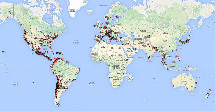
Smartphone network spatial distribution (green and red dots) on December 4, 2015
Meet The Quake-Catcher Network

Quake-Catcher Network
The Quake-Catcher Network is a collaborative initiative for developing the world’s largest, low-cost strong-motion seismic network by utilizing sensors in and attached to internet-connected computers. With your help, the Quake-Catcher Network can provide better understanding of earthquakes, give early warning to schools, emergency response systems, and others. The Quake-Catcher Network also provides educational software designed to help teach about earthquakes and earthquake hazards.
After almost eight years at Stanford, and a year at CalTech, the QCN project is moving to the University of Southern California Dept. of Earth Sciences. QCN will be sponsored by the Incorporated Research Institutions for Seismology (IRIS) and the Southern California Earthquake Center (SCEC).
The Quake-Catcher Network is a distributed computing network that links volunteer hosted computers into a real-time motion sensing network. QCN is one of many scientific computing projects that runs on the world-renowned distributed computing platform Berkeley Open Infrastructure for Network Computing (BOINC).

The volunteer computers monitor vibrational sensors called MEMS accelerometers, and digitally transmit “triggers” to QCN’s servers whenever strong new motions are observed. QCN’s servers sift through these signals, and determine which ones represent earthquakes, and which ones represent cultural noise (like doors slamming, or trucks driving by).
There are two categories of sensors used by QCN: 1) internal mobile device sensors, and 2) external USB sensors.
Mobile Devices: MEMS sensors are often included in laptops, games, cell phones, and other electronic devices for hardware protection, navigation, and game control. When these devices are still and connected to QCN, QCN software monitors the internal accelerometer for strong new shaking. Unfortunately, these devices are rarely secured to the floor, so they may bounce around when a large earthquake occurs. While this is less than ideal for characterizing the regional ground shaking, many such sensors can still provide useful information about earthquake locations and magnitudes.
USB Sensors: MEMS sensors can be mounted to the floor and connected to a desktop computer via a USB cable. These sensors have several advantages over mobile device sensors. 1) By mounting them to the floor, they measure more reliable shaking than mobile devices. 2) These sensors typically have lower noise and better resolution of 3D motion. 3) Desktops are often left on and do not move. 4) The USB sensor is physically removed from the game, phone, or laptop, so human interaction with the device doesn’t reduce the sensors’ performance. 5) USB sensors can be aligned to North, so we know what direction the horizontal “X” and “Y” axes correspond to.
If you are a science teacher at a K-12 school, please apply for a free USB sensor and accompanying QCN software. QCN has been able to purchase sensors to donate to schools in need. If you are interested in donating to the program or requesting a sensor, click here.
BOINC is a leader in the field(s) of Distributed Computing, Grid Computing and Citizen Cyberscience.BOINC is more properly the Berkeley Open Infrastructure for Network Computing, developed at UC Berkeley.
Earthquake safety is a responsibility shared by billions worldwide. The Quake-Catcher Network (QCN) provides software so that individuals can join together to improve earthquake monitoring, earthquake awareness, and the science of earthquakes. The Quake-Catcher Network (QCN) links existing networked laptops and desktops in hopes to form the worlds largest strong-motion seismic network.
Below, the QCN Quake Catcher Network map

ShakeAlert: An Earthquake Early Warning System for the West Coast of the United States

The U. S. Geological Survey (USGS) along with a coalition of State and university partners is developing and testing an earthquake early warning (EEW) system called ShakeAlert for the west coast of the United States. Long term funding must be secured before the system can begin sending general public notifications, however, some limited pilot projects are active and more are being developed. The USGS has set the goal of beginning limited public notifications in 2018.
Watch a video describing how ShakeAlert works in English or Spanish.
The primary project partners include:
United States Geological Survey
California Governor’s Office of Emergency Services (CalOES)
California Geological Survey
California Institute of Technology
University of California Berkeley
University of Washington
University of Oregon
Gordon and Betty Moore Foundation
The Earthquake Threat
Earthquakes pose a national challenge because more than 143 million Americans live in areas of significant seismic risk across 39 states. Most of our Nation’s earthquake risk is concentrated on the West Coast of the United States. The Federal Emergency Management Agency (FEMA) has estimated the average annualized loss from earthquakes, nationwide, to be $5.3 billion, with 77 percent of that figure ($4.1 billion) coming from California, Washington, and Oregon, and 66 percent ($3.5 billion) from California alone. In the next 30 years, California has a 99.7 percent chance of a magnitude 6.7 or larger earthquake and the Pacific Northwest has a 10 percent chance of a magnitude 8 to 9 megathrust earthquake on the Cascadia subduction zone.
Part of the Solution
Today, the technology exists to detect earthquakes, so quickly, that an alert can reach some areas before strong shaking arrives. The purpose of the ShakeAlert system is to identify and characterize an earthquake a few seconds after it begins, calculate the likely intensity of ground shaking that will result, and deliver warnings to people and infrastructure in harm’s way. This can be done by detecting the first energy to radiate from an earthquake, the P-wave energy, which rarely causes damage. Using P-wave information, we first estimate the location and the magnitude of the earthquake. Then, the anticipated ground shaking across the region to be affected is estimated and a warning is provided to local populations. The method can provide warning before the S-wave arrives, bringing the strong shaking that usually causes most of the damage.
Studies of earthquake early warning methods in California have shown that the warning time would range from a few seconds to a few tens of seconds. ShakeAlert can give enough time to slow trains and taxiing planes, to prevent cars from entering bridges and tunnels, to move away from dangerous machines or chemicals in work environments and to take cover under a desk, or to automatically shut down and isolate industrial systems. Taking such actions before shaking starts can reduce damage and casualties during an earthquake. It can also prevent cascading failures in the aftermath of an event. For example, isolating utilities before shaking starts can reduce the number of fire initiations.
System Goal
The USGS will issue public warnings of potentially damaging earthquakes and provide warning parameter data to government agencies and private users on a region-by-region basis, as soon as the ShakeAlert system, its products, and its parametric data meet minimum quality and reliability standards in those geographic regions. The USGS has set the goal of beginning limited public notifications in 2018. Product availability will expand geographically via ANSS regional seismic networks, such that ShakeAlert products and warnings become available for all regions with dense seismic instrumentation.
Current Status
The West Coast ShakeAlert system is being developed by expanding and upgrading the infrastructure of regional seismic networks that are part of the Advanced National Seismic System (ANSS); the California Integrated Seismic Network (CISN) is made up of the Southern California Seismic Network, SCSN) and the Northern California Seismic System, NCSS and the Pacific Northwest Seismic Network (PNSN). This enables the USGS and ANSS to leverage their substantial investment in sensor networks, data telemetry systems, data processing centers, and software for earthquake monitoring activities residing in these network centers. The ShakeAlert system has been sending live alerts to “beta” users in California since January of 2012 and in the Pacific Northwest since February of 2015.
In February of 2016 the USGS, along with its partners, rolled-out the next-generation ShakeAlert early warning test system in California joined by Oregon and Washington in April 2017. This West Coast-wide “production prototype” has been designed for redundant, reliable operations. The system includes geographically distributed servers, and allows for automatic fail-over if connection is lost.
This next-generation system will not yet support public warnings but does allow selected early adopters to develop and deploy pilot implementations that take protective actions triggered by the ShakeAlert notifications in areas with sufficient sensor coverage.
Authorities
The USGS will develop and operate the ShakeAlert system, and issue public notifications under collaborative authorities with FEMA, as part of the National Earthquake Hazard Reduction Program, as enacted by the Earthquake Hazards Reduction Act of 1977, 42 U.S.C. §§ 7704 SEC. 2.
For More Information
Robert de Groot, ShakeAlert National Coordinator for Communication, Education, and Outreach
rdegroot@usgs.gov
626-583-7225
Learn more about EEW Research
ShakeAlert Fact Sheet
ShakeAlert Implementation Plan