
From The DLR German Aerospace Center [Deutsches Zentrum für Luft- und Raumfahrt e.V.](DE)
6.17.24

Establishment of an open geo-zone at the National Experimental Test Center for Unmanned Aircraft Systems.
The defined geographical area is located in the cordoned-off zone of the airport and an uninhabited section to the south. It includes buffer zones (yellow – contingency buffer; red – ground risk buffer) that extend from the UAS flight area (green) to the edge of the geo-zone to prevent the aircraft from leaving the perimeter even in emergency situations. Credit: DLR (CC BY-NC-ND 3.0)
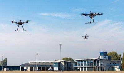
Drones at Magdeburg Cohstedt Airport. DLR

The unmanned DLR helicopter Superartis approaches the wind turbine. DLR
With a view to testing the use of drones in offshore wind farms, the German Aerospace Center (Deutsches Zentrum für Luft- und Raumfahrt; DLR) will be using a geo-zone at the National Experimental Center for Unmanned Aircraft Systems in June 2024 to expand drone operations in the open category. The establishment of this special geographical area makes it possible to fly drones with a take-off mass of up to 800 kilograms outside the direct field of vision at Cochstedt Airport.
____________________
-Unprecedented framework for testing drones
-Enables both DLR researchers and external drone operators to quickly test and develop UASs in real-life
operations.
-Drones with a take-off mass of up to 800 kilograms can fly outside the direct field of vision at
Cochstedt Airport.
-Used initially for the Offshore Drone Challenge organised by EnBW and DLR.
-Focus: Aeronautics, uncrewed flight
____________________
Whether for photography or film footage, transporting goods to remote areas such as offshore wind farms, or monitoring the condition of buildings and agricultural land, drones are being used in an increasingly diverse range of applications. However, there are special restrictions for drones in certain areas, such as airports and their immediate surroundings. Known as geo-zones or geographical UAS (Uncrewed Aerial System) areas, these are portions of airspace where drone operations are facilitated, restricted or excluded. The German Federal Ministry for Digital and Transport (Bundesministerium für Digitales und Verkehr; BMDV) determines geo-zones on the basis of the section 21h of the German Rules of the Air Regulations.
At DLR’s National Experimental Test Center for Unmanned Aircraft Systems at Cochstedt Airport, a geo-zone for the operation of drones in the ‘extended open category’ will be set up for the first time in June 2024, allowing the aircraft to operate without special authorisation within certain boundaries. The DLR Institute of Flight Systems has worked with the German Federal Aviation Office (Luftfahrtbundesamt; LBA) to develop the necessary framework and submit the application to the BMDV for this geo-zone.
“As users of the geo-zone, drone operators must adhere to these requirements in order to guarantee the highest safety standards for experimental operations,” explains Sebastian Cain from the Institute of Flight Systems. Some of the safety requirements, such as airspace monitoring, are already ensured by the established procedures of the National Test Center. Other measures, such as the technical operation of drones by qualified personnel and compliance with strict rules for the flight missions, must be ensured by the drone operator.
Low-risk drone flights at Magdeburg-Cochstedt Airport
The operational framework that has been drawn up is the result of a generalised safety analysis, which in turn is based on the specifications of the SORA (Specific Operational Risk Assessment) procedure, a recognised methodology for the classification of the risk posed by a drone flight in the specific category of operations. The safety analysis showed that drone operations pose a low risk to uninvolved parties, and the specially defined rules for the open geo-zone also enable not only the testing of drones with a maximum take-off mass of 800 kilograms, but also BVLOS (Beyond Visual Line of Sight) flights.
“We are creating an unprecedented framework for the testing of drones. Without compromising on safety, we offer a sandbox for the drone industry that enables new developments without requiring the complex procedures that may be required for authorisations in other European countries,” says Johann Dauer, Head of the Unmanned Aircraft Department at the DLR Institute of Flight Systems.
Geo-zone launching in June 2024
The newly established geo-zone will initially be temporarily active in June 2024 and will play a key role in enabling test flights for the Offshore Drone Challenge. This is the first implementation of a geo-zone that enables drone operations in an extended open category in Germany, a major breakthrough for the testing of UASs in the context of harmonised European drone legislation.
DLR is currently working on the operating conditions for a possible permanent open geo-zone at Cochstedt Airport to make it easier to test UASs in the future. This will enable both DLR researchers and external drone operators to undertake rapid testing and further development of UASs in real-world conditions at the National Experimental Test Center for Unmanned Aircraft Systems.
Testing flight manoeuvres at the Offshore Drone Challenge in Cochstedt
On 19 and 20 June, DLR and the energy supplier EnBW are organising the Offshore Drone Challenge at the National Experimental Test Center for Unmanned Aircraft Systems in Cochstedt. The focus of this competition is the demonstration of a freight transport mission that is relevant in the operation and maintenance logistics for offshore wind farms. During the two-day event, seven drone manufacturers and service providers will be demonstrating their technologies and undergoing various tasks such as picking up and setting down a load with as little manual intervention as possible, or flying out of visual line of sight. The flight demonstrations will be a first step in demonstrating drones’ capabilities in offshore goods transportation.
See the full article for Related articles and Related links with links.
See the full article here.
Comments are invited and will be appreciated, especially if the reader finds any errors which I can correct.

five-ways-keep-your-child-safe-school-shootings
Please help promote STEM in your local schools.
![]()

The DLR German Aerospace Center [Deutsches Zentrum für Luft- und Raumfahrt e.V.](DE) is the national aeronautics and space research centre of the Federal Republic of Germany. Its extensive research and development work in aeronautics, space, energy, transport and security is integrated into national and international cooperative ventures. In addition to its own research, as Germany’s space agency, DLR has been given responsibility by the federal government for the planning and implementation of the German space programme. DLR is also the umbrella organization for the nation’s largest project management agency.
DLR has approximately 10.000 employees at 30 locations in Germany. Institutes and facilities are spread over at 16 locations in Germany: Cologne (headquarters), Augsburg, Berlin, Bonn, Braunschweig, Bremen, Goettingen, Hamburg, Juelich, Lampoldshausen, Neustrelitz, Oberpfaffenhofen, Stade, Stuttgart, Trauen, and Weilheim. DLR also has offices in Brussels, Paris, Tokyo and Washington D.C.
DLR has a budget of €1 billion to cover its own research, development and operations. Approximately 49% of this sum comes from competitively allocated third-party funds (German: Drittmittel). In addition to this, DLR administers around €860 million in German funds for The European Space Agency [La Agencia Espacial Europea] [Agence spatiale européenne][Europäische Weltraumorganization](EU). In its capacity as project management agency, it manages €1.279 billion in research on behalf of German federal ministries. DLR is a full member of the Consultative Committee for Space Data Systems and a member of The Helmholtz Association of German Research Centres.
In the context of DLR’s initiatives to promote young research talent, ten DLR School Labs were set up at The Technical University of Darmstadt [Technische Universität Darmstadt] (DE), The Hamburg University of Technology [Technische Universität Hamburg](DE), RWTH AACHEN UNIVERSITY [Rheinisch-Westfaelische Technische Hochschule(DE), The Technical University Dresden [Technische Universität Dresden](DE) and in Berlin-Adlershof, Braunschweig, Bremen, Cologne-Porz, Dortmund, Göttingen, Lampoldshausen/Stuttgart, Neustrelitz, and Oberpfaffenhofen over the past years. In the DLR School Labs, pupils can become acquainted with the practical aspects of natural and engineering sciences by conducting interesting experiments.
DLR’s mission comprises the exploration of the Earth and the solar system, as well as research aimed at protecting the environment and developing environmentally compatible technologies, and at promoting mobility, communication and security. DLR’s research portfolio, which covers the four focus areas Aeronautics, Space, Transportation and Energy, ranges from basic research to innovative applications. DLR operates large-scale research centres, both for the benefit of its own projects and as a service for its clients and partners from the worlds of business and science.
The objective of DLR’s aeronautics research is to strengthen the competitive advantage of the national and European aeronautical industry and aviation sector, and to meet political and social demands – for instance with regard to climate-friendly aviation. German space research activities range from experiments under conditions of weightlessness to the exploration of other planets and environmental monitoring from space. In addition to these activities, DLR performs tasks of public authority pertaining to the planning and implementation of the German space programme, in its capacity as the official space agency of the Federal Republic of Germany. DLR’s Project Management Agency (German: Projektträger im DLR) has also been entrusted with tasks of public authority pertaining to the administration of subsidies. In the field of energy research, DLR is working on highly efficient, low-CO2 power generation technologies based on gas turbines and fuel cells, on solar thermal power generation, and on the efficient use of heat, including cogeneration based on fossil and renewable energy sources. The topics covered by DLR’s transportation research are maintaining mobility, protecting the environment and saving resources, and improving transportation safety.
In addition to the already existing projects Mars Express, global navigation satellite system Galileo, and Shuttle Radar Topography Mission, the Institute of Space Systems (German: Institut für Raumfahrtsysteme) was founded in Bremen on 26 January 2007. In the future, 80 scientists and engineers will be doing research into topics such as space mission concepts, satellite development and propulsion technology.
Planetary research
Mars Express

The High Resolution Stereo Camera HRSC is the most important German contribution to the European Space Agency’s Mars Express mission. It is the first digital stereo camera that also generates multispectral data and that has a very high resolution lens. The camera records images of the Martian surface which formed the basis for a large number of scientific studies. With the HRSC, which was developed at the German Aerospace Center’s Institute of Planetary Research (German: Institut für Planetenforschung), it is possible to analyze details no larger than 10 to 30 meters in three dimensions.
Rosetta and Philae


The comet orbiter Rosetta is controlled from the European Space Operations Centre (ESOC), in Darmstadt, Germany. The DLR has provided the structure, thermal subsystem, flywheel, the Active Descent System (procured by DLR but made in Switzerland), ROLIS, downward-looking camera, SESAME, acoustic sounding and seismic instrument for Philae, the orbiter’s landing unit. It has also managed the project and did the level product assurance. The University of Münster built MUPUS (it was designed and built in Space Research Centre of Polish Academy of Sciences) and the Braunschweig University of Technology the ROMAP instrument. The MPG Institute for Solar System Research [MPG Institut für Sonnensystemforschung](DE) made the payload engineering, eject mechanism, landing gear, anchoring harpoon, central computer, COSAC, APXS and other subsystems.
Dawn

The framing cameras, provided by the MPG Institute for Solar System Research and the DLR, are the main imaging instruments of Dawn, a multi-destination space probe to the protoplanets 4 Vesta and 1 Ceres launched in 2007. The cameras offer resolutions of 17 m/pixel for Vesta and 66 m/pixel for Ceres. Because the framing cameras are vital for both science and navigation, the payload has two identical and physically separate cameras (FC1 & FC2) for redundancy, each with its own optics, electronics, and structure.
Human spaceflight
Columbus
DLR operates the Columbus Control Centre in Oberpfaffenhofen, Germany. It is responsible for the coordination of scientific activities as well as for systems operations and life support on board the orbiting Columbus laboratory.
In February 2008, the Columbus laboratory, Europe’s core contribution to the International Space Station ISS, was brought into space by the Space Shuttle and docked to the ISS. The cylindrical module, which has a diameter of 4.5 metres (14 ft 9 in), contains state-of-the-art scientific equipment. It is planned to enable researchers on Earth to conduct thousands of experiments in biology, materials science, fluid physics and many other fields under conditions of weightlessness in space.
Spacelab, Shuttle, Mir, Soyuz
Germany has astronauts and participates in ESA human space programs including flights of German astronauts aboard US Space Shuttles and Russian spacecraft. Besides missions under ESA and flights on Soyuz and Mir, two Space Shuttle missions with the European built Spacelab were fully funded and organizationally and scientifically controlled by Germany (like a separate few by ESA and one by Japan) with German astronauts on board as hosts and not guests. The first West German mission Deutschland 1 (Spacelab-D1, DLR-1, NASA designation STS-61-A) took place in 1985.
The second similar mission, Deutschland 2 (Spacelab-D2, DLR-2, NASA designation STS-55), was first planned for 1988, but then due to the Space Shuttle Challenger disaster was delayed until 1993 when it became the first German human space mission after German reunification.
Earth-bound research and aeronautics
Remote sensing of the Earth
In remote sensing of the Earth, satellites provide comprehensive and continually updated information on “System Earth”. This remote sensing data is used to investigate the Earth’s atmosphere, land and ocean surfaces, and ice sheets. Practical applications of this technology include environmental monitoring and disaster relief.
Following the Indian Ocean tsunami of 26 December 2004, for instance, up-to-date maps could be compiled very quickly using Earth observation satellites. These maps could then be used for orientation during relief missions. DLR conducts these research activities at the German Remote Sensing Data Center (DFD) (German: Deutsches Fernerkundungsdatenzentrum), a DLR institute based in Oberpfaffenhofen. Nowadays, satellite data is also important for climate research: it is used to measure temperatures, CO2 levels, particulate matter levels, rainforest deforestation and the radiation conditions of the Earth’s surface (land, oceans, polar ice).
TerraSAR-X

The German Earth observation satellite TerraSAR-X was launched in June 2007. The objective of this five-year mission was to provide radar remote sensing data to scientific and commercial users. The satellite’s design is based on the technology and expertise developed in the X-SAR and SRTM SAR missions (Synthetic Aperture Radar). The sensor has a number of different modes of operation, with a maximum resolution of one meter, and is capable of generating elevation profiles.
TerraSAR-X is the first satellite that was jointly paid for by government and industry. DLR contributed about 80 percent of the total expenses, with the remainder being covered by EADS Astrium. The satellite’s core component is a radar sensor operating in the X band and capable of recording the Earth’s surface using a range of different modes of operation, capturing an area of 10 to 100 kilometers in size with a resolution of 1 to 16 meters.
Astronomical surveys
The Uppsala–DLR Trojan Survey (UDTS) was a search for asteroids near Jupiter in the 1990s, in collaboration with the Swedish Uppsala Astronomical Observatory. When it concluded there was another survey, the Uppsala–DLR Asteroid Survey, this time with a focus on Near Earth asteroids and both surveys discovered numerous objects.
Reusable launch systems
Suborbital Spaceplane
Studying a suborbital spaceplane, DLR conducted Falke prototype for Hermes spaceplane program, participates in non-realized Sanger II project and since 2005 work under the concept making fast intercontinental passenger transport possible. The SpaceLiner is a reusable vehicle lifting-off vertically and landing like a glider.
RETALT
DLR is a partner for RETALT (RETro Propulsion Assisted Landing Technologies), a program aiming to develop two-stage-to-orbit and single-stage to orbit reusable launch systems.
Aircraft design
DLR is involved in different European H2020 projects (AGILE, AGILE4.0) concerning aircraft design with the objective to improve multidisciplinary optimization using distributed analysis frameworks.
Research aircraft
DLR operates Europe’s largest fleet of research aircraft. The aircraft are used both as research objects and as research tools. DLR’s research aircraft provide platforms for all kinds of research missions. Scientists and engineers can use them for practical, application-oriented purposes: Earth observation, atmospheric research or testing new aircraft components. DLR is for instance investigating wing flutter and possible ways of eliminating it, which would also help to reduce aircraft noise. So-called “flying simulators” can be used to simulate the flight performance of aircraft that have not been built yet. This method was for instance used to test the Airbus A380 in the early stages of its development. The VFW 614 ATTAS was used to test several systems.
The high-altitude research aircraft HALO (High Altitude and Long Range Research Aircraft) will be used for atmospheric research and Earth observation from 2009. With a cruising altitude of more than 15 kilometers and a range of over 8,000 kilometers, HALO will provide for the first time the capability to gather data on a continental scale, at all latitudes, from the tropics to the poles, and at altitudes as high as the lower stratosphere.
The Airbus A320-232 D-ATRA, the latest and largest addition to the fleet, has been in use by the German Aerospace Center since late 2008. ATRA (Advanced Technology Research Aircraft) is a modern and flexible flight test platform which sets a new benchmark for flying test beds in European aerospace research – and not just because of its size.
DLR and NASA jointly operated the flying infrared telescope SOFIA (Stratospheric Observatory for Infrared Astronomy). A Boeing 747SP with a modified fuselage enabling it to carry a reflecting telescope developed in Germany was used as an airborne research platform. The aircraft was operated by the Dryden Flight Research Center at Site 9 (USAF Plant 42) in Palmdale, California. Observation flights were flown 3 or 4 nights a week, for up to eight hours at a time and at an altitude of 12 to 14 kilometers. SOFIA was designed to remain operational for a period of 20 years. It is the successor to the Kuiper Airborne Observatory (KAO), which was deployed from 1974 to 1995.
On 31 January 2020, the DLR put its newest aircraft into service, a Falcon 2000LX ISTAR (In-flight Systems & Technology Airborne Research).
Emissions research
DLR conducts research into CO2 and noise emissions caused by air transport. In order to ensure that increasing traffic volumes do not lead to an increase in the noise pollution caused by air transport, DLR is investigating options for noise reduction. The “Low-noise Approach and Departure Procedures” research project (German: Lärmoptimierte An- und Abflugverfahren), for instance, forms part of the national research project “Quiet Traffic” (German: Leiser Verkehr). The objective of this project is to find flight procedures that can reduce the amount of noise generated during takeoff and landing. One approach is to analyse noise propagation at ground level during takeoff using a large number of microphones. Researchers are also trying to reduce the noise at source, focusing for instance on airframe and engine noise. They hope to minimize noise generated in the engines using so-called “antinoise”.
The German Aerospace Center’s research work on CO2 emissions caused by air transport focuses for instance on model calculations concerning the effects of converting the global aircraft fleet to hydrogen propulsion. The growth rates of aviation are above average. This raises the question if CO2 emission-free hydrogen propulsion could perhaps limit the effects of growing air traffic volumes on the environment and the climate.
Hydrogen as an energy carrier
The Hydrosol and Hydrosol-2 is one of the energy research projects in which DLR scientists are engaged. For the first time, scientists have achieved thermal water splitting using solar energy, generating hydrogen and oxygen without CO2 emissions. For this achievement, the DLR team and several other research groups received the Descartes Prize, a research award created by the European Commission. The FP6 Hydrosol II pilot reactor (around 100 kW) for solar thermochemical hydrogen production at the Plataforma Solar de Almería in Spain started in November 2005 and is in operation since 2008.
Traffic Congestion
During the 2006 FIFA World Cup football championship, DLR implemented the Soccer project aimed at preventing traffic congestion. In this transportation research project, traffic data was obtained from the air in Berlin, Stuttgart and Cologne and used as input for traffic forecasting. A sensor system combining a conventional and a thermographic camera was used to obtain the data. A zeppelin, an aeroplane and a helicopter served as flying research platforms. An image analysis software package generated aerial photos showing the current traffic parameters as well as traffic forecasts. In this way, traffic control centres could be provided with almost-real-time traffic information, and road users could be diverted whenever necessary.
Solar tower power plant
In 2007, the first commercially operated solar tower power plant, the PS10 solar power tower, was commissioned. It has a capacity of eleven megawatt and it is located near Sevilla, in Sanlúcar la Mayor (Spain). DLR is prominently involved in developing the technology for this type of power plant. In solar tower power plants, sun-tracking mirrors (heliostats) redirect the solar radiation onto a central heat exchanger (receiver) on top of a tower. This generates high-temperature process heat, which can then be used in gas or steam turbine power plants to generate electrical power for the public electricity grid. In the future, solar thermal tower plant technology could also be used to generate solar fuels, such as hydrogen, without CO2 emissions.
