
The ShakeAlert System, managed by the United States Geological Survey (USGS), is constantly being upgraded to improve alert speed and accuracy. It is extremely important to be able to quickly estimate the location and magnitude of major earthquakes so that alerts can rapidly be delivered to everyone in the affected areas.
Scientists at the Pacific Northwest Seismic Network (PNSN) have developed a new geodetic algorithm called GFAST (Geodetic First Approximation of Size and Time) that will improve ShakeAlert’s ability to quickly characterize the magnitude of the next Big One. ShakeAlert is the world’s first earthquake early warning system that incorporates geodetic data and algorithms.
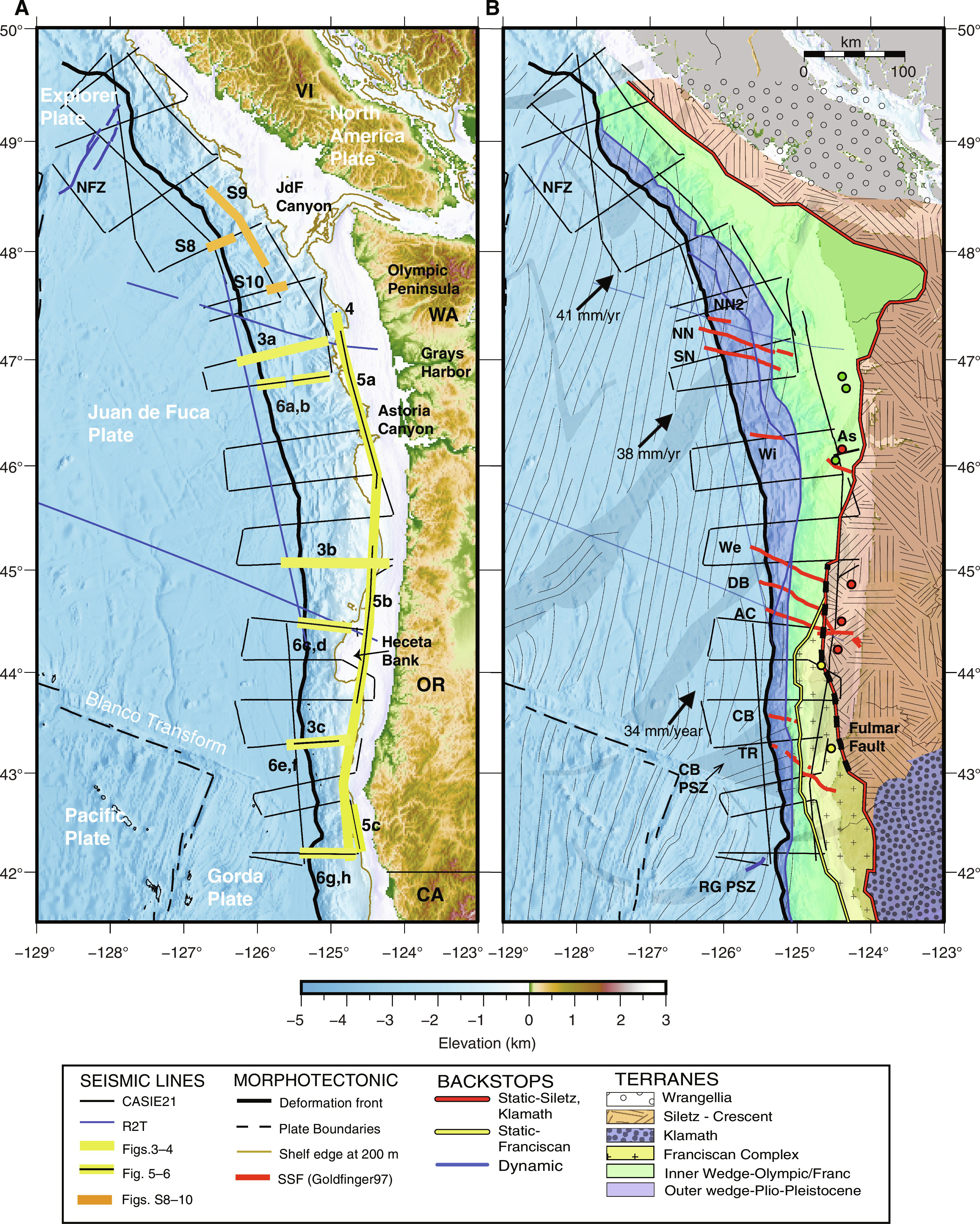
ShakeAlert uses real-time data from over 1500 seismic sensors and now, with the incorporation of the GFAST algorithm, utilizes data from over 760 Global Navigation Satellite System (GNSS) sensors for rapid earthquake detection. GNSS includes the well-known US-based Global Positioning System (GPS) as well as other satellite-based positioning systems used across the globe. Seismometers measure how quickly the earth is shaking in terms of velocity or acceleration. GNSS geodetic sensors measure how far the ground moves up, down, or sideways as a result of an earthquake. Small earthquakes cause small localized shifts. Larger magnitude earthquakes have greater velocity and acceleration of shaking as well as cause more extensive permanent ground displacement. During a Cascadia Subduction Zone earthquake, the ground could shift down and westward by several meters!
GFAST was developed by PNSN researchers Brendan Crowell and Carl Ulberg, who work at the University of Washington. Research was also contributed by Diego Melgar, who directs the Cascadia Region Earthquake Science Center at the University of Oregon, and Jessica Murray of the USGS. Crowell and Melgar began developing the theory that peak ground displacement is analogous to earthquake magnitude in the early 2010s as part of their PhD research at the Scripps Institution of Oceanography. Crowell then used funds donated to the PNSN by the Gordon and Betty Moore Foundation and the Amazon Catalyst Program to develop the methodology and code base for the early GFAST algorithm and convert it to a format that was compatible with the ShakeAlert System. Additional funds from the USGS Earthquake Hazards and NASA Disasters programs helped to further refine the GFAST architecture.
In the early 2020s, Ulberg and others in ShakeAlert’s Software Management Working Group began integrating GFAST messages into the ShakeAlert solution aggregator. This aggregator was designed to evaluate the results of the two other earthquake detection algorithms already used by ShakeAlert and provide a definitive estimate of the detected earthquake’s size and location. Those existing algorithms, EPIC (Earthquake Point‐source Integrated Code) and FinDer (Finite‐Fault Rupture Detector), solely use data from seismic stations.
Ulberg created new logic within the ShakeAlert solution aggregator and GFAST itself in order to decide when and how to use GFAST in addition to EPIC and FinDer. For example, GFAST had to understand how many geodetic stations needed to provide data and how much displacement was required before an estimated magnitude would be considered reliable. It also had to weed out background “noise” from geodetic stations that could lead to false alerts. GFAST cannot reliably detect small and moderate earthquakes and works best in conjunction with seismic algorithms which can determine when and where earthquakes originate. For this reason, GFAST will start augmenting EPIC and FinDer for M7+ earthquakes and will become increasingly important the larger an earthquake grows.
Ulberg was also involved with testing the algorithm alongside colleagues from the USGS. The System Testing and Performance Group generated dozens of earthquake simulations to ensure that GFAST would perform well. It took around 10 years to create and test GFAST before it was finally ready to be fully integrated into the ShakeAlert System.
The earthquake early warning alerts received by end-users will look exactly the same and the speed of earthquake detection will not change. The public will not notice a difference but will benefit from the improved event size accuracy and more comprehensive alerting regions.
There are several ways that Oregonians and Washingtonians can receive earthquake early warning alerts on their cell phones. Alerts can be delivered via texts from the Wireless Emergency Alert System, push notifications from the Android Operating System, and push notifications from free ShakeAlert-powered apps like MyShake. To ensure alert delivery, make sure that your phone’s operating system is updated and that Emergency Alerts are turned on in its settings. iPhone users should also turn on Local Awareness. Learn more from theUSGS website.
From ShakeAlert: An Earthquake Early Warning System for the West Coast of the United States

ShakeAlert is an earthquake early warning system (EEW) in the United States, developed and operated by the United States Geological Survey (USGS) and its partners. As of 2021, the system issues alerts for the country’s West Coast (specifically the states of California, Oregon and Washington). It is expected that the system will be expanded to other seismically active areas of the United States in the future.
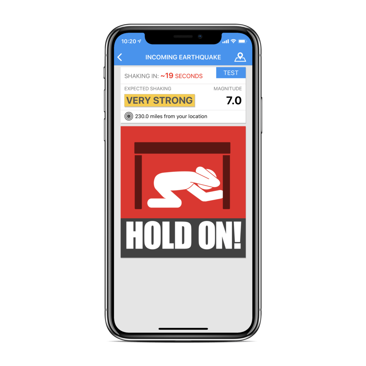
Similar to other earthquake early warning systems, ShakeAlert does not predict earthquakes, but rather it attempts to quickly identify a seismic event and issue an alert before widespread shaking is felt. It does this by detecting an earthquake’s fast moving (but weak) P waves, then computes the event’s location and estimated magnitude, after which it issues the warning. Depending on a person’s distance from the earthquake’s epicenter, the alert may reach them before the earthquake’s slower moving (but destructive) S waves do. These warnings can provide time for persons to take protective actions, such as “drop, cover and hold on,” and for organizations to shut down transit systems, equipment, open fire station doors, and trigger specific protocols in hospitals and other sensitive work environments.
Research and development of the system began in 2006 and by the fall of 2018, the system was considered “sufficiently functional and tested” to enter phase 1 and begin issuing alerts for the West Coast states. While the warnings are generated by ShakeAlert, USGS does not send the alerts directly, instead relying on various private and public partners to distribute the messages through systems such as Wireless Emergency Alerts (WEA) and mobile apps. A statewide alert distribution system went online in California on October 17, 2019, in Oregon on March 11, 2021, and in Washington on May 4, 2021.
Long term funding must be secured before the system can begin sending general public notifications, however, some limited pilot projects are active and more are being developed.
Initially the system has been developed to monitor and alert the West Coast of the United States, an area with significant seismic risk due to the San Andreas fault zone and the Cascadia subduction zone.


Watch a video describing how ShakeAlert works in English or Spanish.
The primary project partners include:
United States Geological Survey
California Governor’s Office of Emergency Services (CalOES)
California Geological Survey California Institute of Technology
University of California Berkeley
University of Washington
University of Oregon
Gordon and Betty Moore Foundation
The Swiss Federal Institute of Technology in Zürich (ETH Zurich).
Of the 1,675 seismic stations needed for full implementation of the West Coast system, only 1,115 had been built or funded by April 2018 (67% of the total needed). The project continues to solicit property owners for permission to place new seismic stations.
Following the 2020 Salt Lake City earthquake, local media reported that Utah was the next state in line to get ShakeAlert.
![]()
![]()
Earthquake Network project smartphone ap is a research project which aims at developing and maintaining a crowdsourced smartphone-based earthquake warning system at a global level. Smartphones made available by the population are used to detect the earthquake waves using the on-board accelerometers. When an earthquake is detected, an earthquake warning is issued in order to alert the population not yet reached by the damaging waves of the earthquake.
The project started on January 1, 2013 with the release of the homonymous Android application Earthquake Network. The author of the research project and developer of the smartphone application is Francesco Finazzi of the University of Bergamo, Italy.
Get the app in the Google Play store.
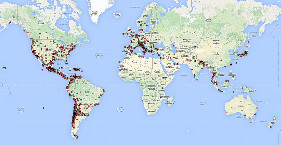
Smartphone network spatial distribution (green and red dots) on December 4, 2015
About Early Warning Labs, LLC
Early Warning Labs, LLC (EWL) is an Earthquake Early Warning technology developer and integrator located in Santa Monica, CA. EWL is partnered with industry leading GIS provider ESRI, Inc. and is collaborating with the US Government and university partners.
EWL is investing millions of dollars over the next 36 months to complete the final integration and delivery of Earthquake Early Warning to individual consumers, government entities, and commercial users.
EWL’s mission is to improve, expand, and lower the costs of the existing earthquake early warning systems.
EWL is developing a robust cloud server environment to handle low-cost mass distribution of these warnings. In addition, Early Warning Labs is researching and developing automated response standards
and systems that allow public and private users to take pre-defined automated actions to protect lives and assets.
EWL has an existing beta R&D test system installed at one of the largest studios in Southern California. The goal of this system is to stress test EWL’s hardware, software, and alert signals while improving latency and reliability.
The Earthquake Threat
Earthquakes pose a national challenge because more than 143 million Americans live in areas of significant seismic risk across 39 states. Most of our Nation’s earthquake risk is concentrated on the West Coast of the United States. The Federal Emergency Management Agency (FEMA) has estimated the average annualized loss from earthquakes, nationwide, to be $5.3 billion, with 77 percent of that figure ($4.1 billion) coming from California, Washington, and Oregon, and 66 percent ($3.5 billion) from California alone. In the next 30 years, California has a 99.7 percent chance of a magnitude 6.7 or larger earthquake and the Pacific Northwest has a 10 percent chance of a magnitude 8 to 9 megathrust earthquake on the Cascadia subduction zone.
Part of the Solution
Today, the technology exists to detect earthquakes, so quickly, that an alert can reach some areas before strong shaking arrives. The purpose of the ShakeAlert system is to identify and characterize an earthquake a few seconds after it begins, calculate the likely intensity of ground shaking that will result, and deliver warnings to people and infrastructure in harm’s way. This can be done by detecting the first energy to radiate from an earthquake, the P-wave energy, which rarely causes damage. Using P-wave information, we first estimate the location and the magnitude of the earthquake. Then, the anticipated ground shaking across the region to be affected is estimated and a warning is provided to local populations. The method can provide warning before the S-wave arrives, bringing the strong shaking that usually causes most of the damage.
Studies of earthquake early warning methods in California have shown that the warning time would range from a few seconds to a few tens of seconds. ShakeAlert can give enough time to slow trains and taxiing planes, to prevent cars from entering bridges and tunnels, to move away from dangerous machines or chemicals in work environments and to take cover under a desk, or to automatically shut down and isolate industrial systems. Taking such actions before shaking starts can reduce damage and casualties during an earthquake. It can also prevent cascading failures in the aftermath of an event. For example, isolating utilities before shaking starts can reduce the number of fire initiations.
System Goal
The USGS will issue public warnings of potentially damaging earthquakes and provide warning parameter data to government agencies and private users on a region-by-region basis, as soon as the ShakeAlert system, its products, and its parametric data meet minimum quality and reliability standards in those geographic regions. The USGS has set the goal of beginning limited public notifications in 2018. Product availability will expand geographically via ANSS regional seismic networks, such that ShakeAlert products and warnings become available for all regions with dense seismic instrumentation.
Current Status
The West Coast ShakeAlert system is being developed by expanding and upgrading the infrastructure of regional seismic networks that are part of the Advanced National Seismic System (ANSS); the California Integrated Seismic Network (CISN) is made up of the Southern California Seismic Network, SCSN) and the Northern California Seismic System, NCSS and the Pacific Northwest Seismic Network (PNSN). This enables the USGS and ANSS to leverage their substantial investment in sensor networks, data telemetry systems, data processing centers, and software for earthquake monitoring activities residing in these network centers. The ShakeAlert system has been sending live alerts to “beta” users in California since January of 2012 and in the Pacific Northwest since February of 2015.
In February of 2016 the USGS, along with its partners, rolled-out the next-generation ShakeAlert early warning test system in California joined by Oregon and Washington in April 2017. This West Coast-wide “production prototype” has been designed for redundant, reliable operations. The system includes geographically distributed servers, and allows for automatic fail-over if connection is lost.
This next-generation system will not yet support public warnings but does allow selected early adopters to develop and deploy pilot implementations that take protective actions triggered by the ShakeAlert notifications in areas with sufficient sensor coverage.
Authorities
The USGS will develop and operate the ShakeAlert system, and issue public notifications under collaborative authorities with FEMA, as part of the National Earthquake Hazard Reduction Program, as enacted by the Earthquake Hazards Reduction Act of 1977, 42 U.S.C. §§ 7704 SEC. 2.
For More Information
Robert de Groot, ShakeAlert National Coordinator for Communication, Education, and Outreach
rdegroot@usgs.gov
626-583-7225
ShakeAlert Implementation Plan
Earthquake Early Warning Introduction
The United States Geological Survey (USGS), in collaboration with state agencies, university partners, and private industry, is developing an earthquake early warning system (EEW) for the West Coast of the United States called ShakeAlert. The USGS Earthquake Hazards Program aims to mitigate earthquake losses in the United States. Citizens, first responders, and engineers rely on the USGS for accurate and timely information about where earthquakes occur, the ground shaking intensity in different locations, and the likelihood is of future significant ground shaking.
The ShakeAlert Earthquake Early Warning System recently entered its first phase of operations. The USGS working in partnership with the California Governor’s Office of Emergency Services (Cal OES) is now allowing for the testing of public alerting via apps, Wireless Emergency Alerts, and by other means throughout California.
ShakeAlert partners in Oregon and Washington are working with the USGS to test public alerting in those states sometime in 2020.
ShakeAlert has demonstrated the feasibility of earthquake early warning, from event detection to producing USGS issued ShakeAlerts ® and will continue to undergo testing and will improve over time. In particular, robust and reliable alert delivery pathways for automated actions are currently being developed and implemented by private industry partners for use in California, Oregon, and Washington.
Earthquake Early Warning Background
The objective of an earthquake early warning system is to rapidly detect the initiation of an earthquake, estimate the level of ground shaking intensity to be expected, and issue a warning before significant ground shaking starts. A network of seismic sensors detects the first energy to radiate from an earthquake, the P-wave energy, and the location and the magnitude of the earthquake is rapidly determined. Then, the anticipated ground shaking across the region to be affected is estimated. The system can provide warning before the S-wave arrives, which brings the strong shaking that usually causes most of the damage. Warnings will be distributed to local and state public emergency response officials, critical infrastructure, private businesses, and the public. EEW systems have been successfully implemented in Japan, Taiwan, Mexico, and other nations with varying degrees of sophistication and coverage.
Earthquake early warning can provide enough time to:
Instruct students and employees to take a protective action such as Drop, Cover, and Hold On
Initiate mass notification procedures
Open fire-house doors and notify local first responders
Slow and stop trains and taxiing planes
Install measures to prevent/limit additional cars from going on bridges, entering tunnels, and being on freeway overpasses before the shaking starts
Move people away from dangerous machines or chemicals in work environments
Shut down gas lines, water treatment plants, or nuclear reactors
Automatically shut down and isolate industrial systems
However, earthquake warning notifications must be transmitted without requiring human review and response action must be automated, as the total warning times are short depending on geographic distance and varying soil densities from the epicenter.
GNSS-Global Navigational Satellite System
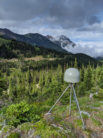
GNSS station | Pacific Northwest Geodetic Array, Central Washington University
__________________________________________
